
By Scott Etkin
Last weekend, two New York City agencies issued an advisory that “excessive rainfall” could cause flash flooding on Sunday and Monday. Department of Environmental Protection Commissioner Rohit T. Aggarwala blamed climate change for “bringing more intense and dangerous weather” and advised city residents to prepare with steps such as elevating items located in their basements.
To many, this sounded like déjà vu. At the end of June there was a similar warning, advising people to travel with caution, check on those with mobility issues, and prepare to move out of basement units prone to flooding.
There’s another underlying message in these advisories from city agencies to city residents: get used to it. More frequent extreme weather events are a symptom of climate change – this summer has brought the hottest days on Earth ever recorded, widespread heatwaves, fatal flooding, and unprecedented wildfire smoke – which is likely to worsen in the years to come. While all of these types of emergencies present challenges for New York City, flooding is of particular concern given its 520 miles of waterfront and many low-lying neighborhoods.
In the end, this past weekend’s storm largely bypassed New York City. But just a bit north of the city, in the Hudson Valley, historically significant rainfall caused catastrophic flooding, damaging homes, businesses, roadways, and railroads, and taking at least one life. Metro-North train service into New York City from northern Westchester is getting back to normal now, but it was significantly disrupted earlier in the week, and a number of roads remain out of service. And all types of debris and pollutants that washed into the Hudson River will make their way south from the Hudson Valley as the river flows to the Atlantic.

Given the increasing recurrence of heavy rains, the Upper West Side is fortunate to be located on some of the city’s most elevated terrain. A flood hazard map from the Department of City Planning, which shows how the floodplain is expected to expand in the decades to come, predicts that the 2050 floodplain on the UWS will encroach into Riverside Park, but not reach into residential areas. It’s a different story on the Upper East Side, which shows flood areas stretching all the way from the East River to 5th Avenue – indicating how risks can vary even among nearby neighborhoods.
Still, there have been numerous reports of flooding among businesses on the UWS in recent years, leading to closures and costly damage. That’s because the city’s persistent flooding problems are not just a matter of geography. They are also affected by the city’s sewage system, which can be overwhelmed by drenching rainfall, and by the very material from which the city is built.
Even a typical rain storm in New York City can negatively impact water quality in the rivers and estuaries which surround us. Sixty percent of New York City uses a 150-year-old combined sewer system, which means that rainfall and wastewater from buildings are both funneled into the same pipes. A little bit of rain – a twentieth of an inch per hour, according to Riverkeeper, a clean water advocacy group – is enough to cause a “combined sewer outflow” (CSO), channeling raw sewage into the city’s surrounding rivers. This is bad news for wildlife, beachgoers, and triathletes, at least for the first several days after a storm, when water quality deteriorates until the natural tidal action of the harbor can flush out and dilute pollutants.

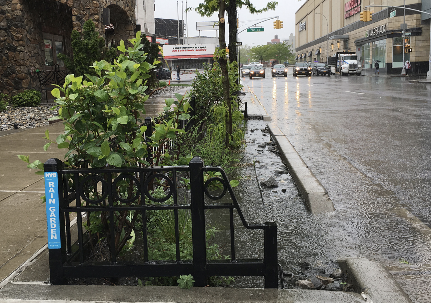
To improve the city’s resistance to flooding, the environmental protection department is pursuing infrastructure projects that absorb rainfall, or at least slow it down on its way into sewers. For example, the city has built thousands of “rain gardens,” which look like extended tree beds with a cutout to allow water to flow into the garden before it reaches the street storm drain. The department’s interactive Green Infrastructure Map shows that there’s only one green project on the Upper West Side (on 104th Street). The vast majority are in Queens and Brooklyn, likely due to the increased flood risk posed by the low-lying geography of those areas.
Another step the city is taking to counteract flooding is rebuilding roads with more permeable alternatives to asphalt. More than 11,000 square feet in the city’s Rockaway neighborhood in Queens was recently rebuilt with porous pavement, which will allow 1.3 million gallons of stormwater to be absorbed into the ground each year, according to the city Department of Design and Construction’s announcement.
Despite these steps, the website of the city’s environmental protection department cautions that “it may take years before residents see the full benefits of these improvements.” Riverkeeper wants the state to adopt more stringent rules under the Federal Clean Water Act, requiring New York City to target swimmable water quality standards in New York City’s waterways. This would force the city to move more quickly to reduce the outflows that can dump raw sewage into rivers during storms. There are seven outflow points along the edge of Riverside Park from 59th Street to 110th Street, according to a map of CSOs from the city.
According to Riverkeeper Senior Director for Advocacy, Policy, and Planning Dan Shapley, “PlaNYC [the city’s sustainability plan] set the goal of eliminating sewage discharges by 2060. What we don’t see is the actual plan to achieve that. The goal has been set by the mayor’s office now. Now we need to see how the city could actually achieve that. And the state needs to help as well.”
In the meantime, to reduce sewage outflows into the Hudson and other city waterways, the city encourages residents to voluntarily reduce their water use when it’s raining. This means waiting until after the storm to shower and not running the faucet while shaving, brushing teeth, or washing dishes. You can sign up for alerts and find more water saving tips here.
Property owners can also take steps to reduce the burden on the city’s waterways. By installing a “green roof” – covering the roof with vegetation and soil atop a waterproof membrane – buildings can absorb a significant amount of rainfall. (Green roofs also have the side benefit of keeping buildings cooler during the summer.)
The city has grants available to cover up to 100% of the costs of the design and construction for green infrastructure projects. As torrential rain becomes more common in the city, these types of interventions are all the more urgent and necessary.
With additional reporting by Daniel Katzive.


More trees and underbrush in our parks and lining our streets would do wonders.
I thought there was a water absorbing “swale” tree garden on the west sidewalk of Columbus Ave just north of 76th St – along with the curved tree gardens and benches outside the school/flea market playground. Maybe the “swale” was a DEP experiment- I remember looking up the program after I noticed it and read the explainer – they involve curb cuts and deeper tree gardens and are good for taking in street water, and also good for the trees, per the findings from various trials in different boroughs.
Hoax
Did you see what happened in Vermont last week?
Restaurant sheds worsen the problem – impact water flow
No, they don’t worsen the problem. They are sitting on impervious asphalt which already drained into the sewer system.
The sheds are an issue – trash accumulates under sheds and can block water
Plant more trees, build walls, curbs.
Think or Swim!
And yet the City wants to make basement apartments legal! It allows building to be built right on the banks of the rivers or in the river. It allows the destruction of the gardens behind brownstones that provided light air and vegetation including trees to flourish. It allows massive Supertalls that exacerbate the problem And doesn’t. Engage in basic storm drain maintenance. Like cleaning out street drains.
The hazards are real but the commitment to doing even the most basic tasks to lessen the impact is lacking and is replaced instead with rhetoric that is not backed by action.