
By Rob Garber for the Bloomingdale Neighborhood History Group
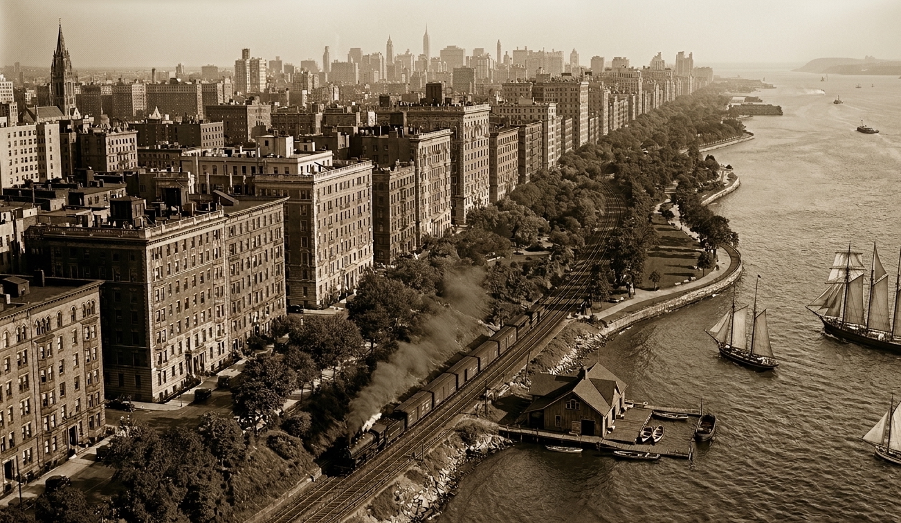
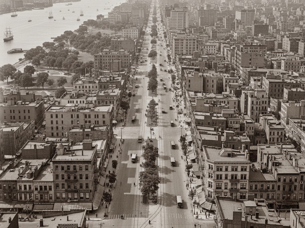
Welcome to another installment in the Rag’s Historical Photo Challenge. This week we feature a real treat— two images of the Upper West Side from a private collection, which the owner believes have never been published before. Can you figure out where and when they were taken, and what they show? Look closely; this week’s challenge photos, like the others in the series, include clues that will help you identify the scene, if you’re a dedicated UWS history sleuth. And even if you don’t recognize the pictures—not to worry! I’ll decode them for you, show you the clues that help identify them, and—best of all—tell you a story the images unlock, because this column isn’t just a test of your neighborhood knowledge; it’s also a rolling celebration of the people, buildings and events that wove the tapestry of the Upper West Side.
Ready? If you think you know where and when the photos were taken and what they show, post your answer as a comment on this column.
If you’ve missed any columns in this series,If you’ve missed any pictures in this series, here is the complete collection.
About the author: Rob Garber has lived on the Upper West Side since the late 20th century and is a member of the Bloomingdale Neighborhood History Group. To learn more, visit their website at upperwestsidehistory.org. All photos in Upper West Side Historical Photo Challenge are used by permission.
Subscribe to West Side Rag’s FREE email newsletter here. And you can Support the Rag here.


I’m guessing they are both AI. The sailing ship in the top is only slightly larger then the rowboat, and are too close to shore. And the bottom pic has Broadway too close to the river. And of course the date of publication is suspect.
Was wondering about that full sail too.
Seems too close to the shore without something like a tugboat.
Consider: It’s April Fools and it’s a “bonus edition”, without an answer the previous challenge.
Yeah, the ships under full sail right at the riverbank are the real give away in the first one.
And that ain’t Broadway or Riverside Park in the second photo.
Both images seem fake.
Where does Riverside Drive appear straight for so long a stretch without building fronts bending to the contour of the winding street?
Where could the bottom picture have been taken from?
I date these photos to April 1! #1 has the Columbia Yacht Club on the river at W 86th St, but where’s the Normandie on Riverside Drive. #2 appears to have transplanted Park Ave to West End Ave.
Cool, but not real.
In the bottom photo all the vehicles are the same. Also there are not any open cross streets in the bottom photo on the right. There is a near total lack of window shades or curtains.
Both photos are of what is now Riverside Drive looking south and the Westide Highway looking north, taken around 1905-1910, hence the sailing ships in the Hudson, the steam locomotive and the garage sign on the building below. On the cusp of automobiles coming.
Haha! I love it! And happy April Fools Day to you too!
While the date of publication may be a give-away, and even if these photos are AI-generated, which I doubt, they are still within possibility. The top photo, of course, would have to be RSD, likely below 72nd Street, since all the buildings are “full-height,” and there are many shorter buildings along RSD above 72nd Street.
As for the second, someone suggested that if this is Broadway, it is too close to the river. Yet you can “see” WEA and RSD, so I don’t think that is the issue with the photo.
The issue with both photos is that they are too “homogeneous.” All the “variations” one would expect to see on both RSD and Bway are not there.
So my guess is that this IS an April Fool’s posting.
*south of Lincoln Towers
WEA below 72nd street was a huge long -term parking lot as late as the mid 90s (?), before all the luxury glass and steel apartments started to pop up.
Manhattan middle class car owners who didn’t want to deal with the alternate side street shuffle were able to store their personal vehicles for a reasonable monthly payment.
I think the Con Ed (?) building was south of the parking lots.
Yes. I parked my ancient Honda at a lot on the 500 block just north of Con Ed, so close to the river that the wind would nearly knock you off your feet. Not the most convenient, but dirt cheap.
These photos clearly depict the Slopville neighborhood of the UWS, the first from the vantage point of the West River, the second a view up now-demapped Moses Avenue. I could be more specific if the images had not been left-right flipped — no fair, Rob!
😀 You win the April 1 contest.
April Fool’s!
🙂
I’d say the top is Riverside Park in the 1920’s and the bottom is Broadway in the 1910’s
I find that promontory where Jersey City would be in the first photo to be particularly amusing.
Ah, the alternate universe photos! April Fools, y’all!
Top photo: looking south along what is now Riverside Drive/w79th. The old yacht club/boat house in the foreground.
Bottom photo: looking north along Broadway from around w72nd.
Both: circa 1910
Top photo could not be as you suggest since every building is a “full-height” building, and even today there are many shorter buildings, including townhouses, along RSD below 79th Street.
The buildings on RSD in #! are 6-8 stories. Buildings of 12-16 stories were not built until the 1920s when it was felt that elevators were safe. Most of the buildings built before then when Riverside Avenue (its first name) opened in 1880. I would bet that the photo is from the 1890s. Many of the 6-8 story buildings were replaced with bigger buildings. The Columbia yacht club means 86th street.
Grand Concourse in Flushing,Brooklyn
Has to be the 79th Street Boat Basin
Out of the corner of my eye I just misread the “Bonus Edition” in this column’s title as “Bogus Edition” — ha ha, how silly of me!
The skyscrapers in the distant horizon of the top pic anachronistic