
By Rob Garber for the Bloomingdale Neighborhood History Group
Welcome to another installment in the Rag’s Historical Photo Challenge. The image above was taken somewhere on the Upper West Side, sometime in the past. Can you figure out where, when, and what it shows? Look closely; this week’s challenge photo, like the others in the series, includes clues that will help you identify the scene, if you’re a dedicated UWS history sleuth. And even if you don’t recognize the picture—not to worry! Come back in two weeks and I’ll decode it, show you the clues that help identify it, and—best of all—tell you a story the image unlocks, because this column isn’t just a test of your neighborhood knowledge; it’s also a rolling celebration of the people, buildings and events that wove the tapestry of the Upper West Side.
Ready? If you think you know where and when the photo was taken and what it shows, post your answer as a comment on this column.
Solution to Historical Photo Challenge #22
Subject: Railroad roundhouse and transfer bridges
Location: Hudson River between West 68th and 72nd streets
Date: September 1927
Image Source: The Hamilton Aerial Map of Manhattan
Clues: Railroad buffs recognized this image in a heartbeat—Hudson River, roundhouse, barges carrying railroad cars. From street level, so much has changed since 1927: the West Side Highway, large apartment buildings on Riverside Boulevard from 68th to 70th Streets, and the disappearance of the industrial west side. But an enclave of lovely apartment buildings remains on West 70th and 71st Streets, looking just as they did 100 years ago. There was one other clue that you Riverside Park experts might have spotted: the Henry Hudson Monument in the corner of the park at 72nd Street, at the spot where Eleanor Roosevelt now holds court …
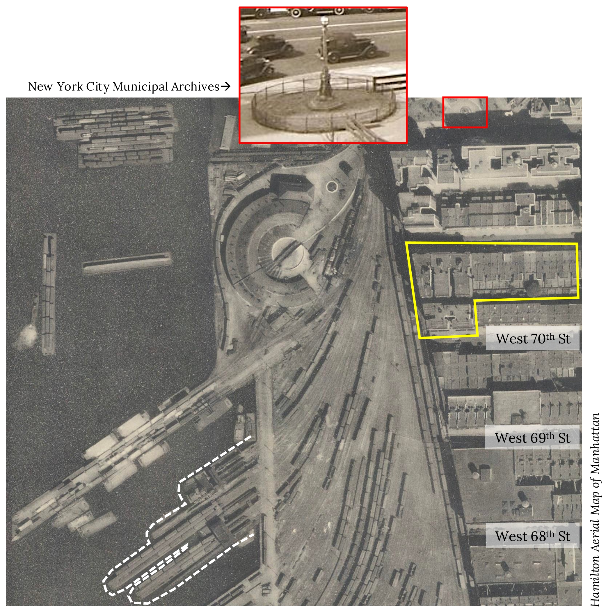
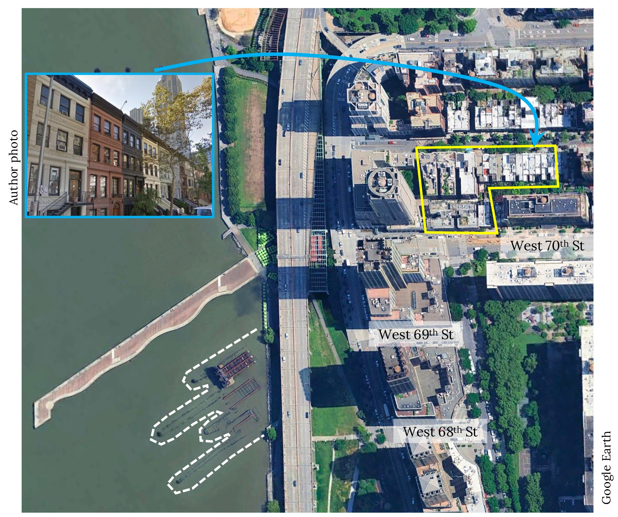
The rest of the story: No single image can capture the lost industrial strength of Manhattan, where manufacturing jobs outnumbered all other categories of employment until the mid-1960s (!) However, this outstanding aerial photograph, taken from 10,000 feet by William Hamilton in 1927, shows New York City industry in one of its most muscular forms: a railroad yard, not for passenger trains but for handling massive amounts of commercial products flowing into and out of New York, from books to automobiles to onions and everything in between. Perhaps the most interesting component of the vast 60th Street Terminal was the set of float bridges. These massive structures performed an extraordinary operation: they took barges that had been floated from New Jersey, each bearing up to 22 loaded railcars, and with the aid of short, powerful engines brought them onshore to be emptied or sorted into trains for further movement to points east, especially Long Island. Rail aficionados and former employees who worked at the 60th Street yard—they’re still around—have prepared detailed articles devoted to this complex system, called a “carfloat.” No brief column can do it justice, but at its heart were the transfer or float bridges. The bridge was anchored to land but projected into the river, so the barges never touched the shore, and train cars could move continuously from rails on the barge to rails on the bridge to rails on land. The overhead structure resembles a gantry crane, but it’s not—the cars were pulled off rather than lifted. Imagine the engineering challenges in designing, building, and operating a structure that could handle such loads while still flexing with the river’s three-dimensional movements! The facility at West 69th Street in fact contained three different types of float bridges, and remnants of all three are still in place—burned, twisted, partially sunken and yet miraculously recognizable. The one in best condition is James B. French’s “contained apron” design, completed in 1911 and in operation for more than 50 years. Head down to the ever-evolving, ever-improving Riverside Park South and contemplate all the goods that moved through the bridge that still stands proudly and would have continued its work had not standardized shipping containers and the post-World War II trucking industry changed port facilities forever.
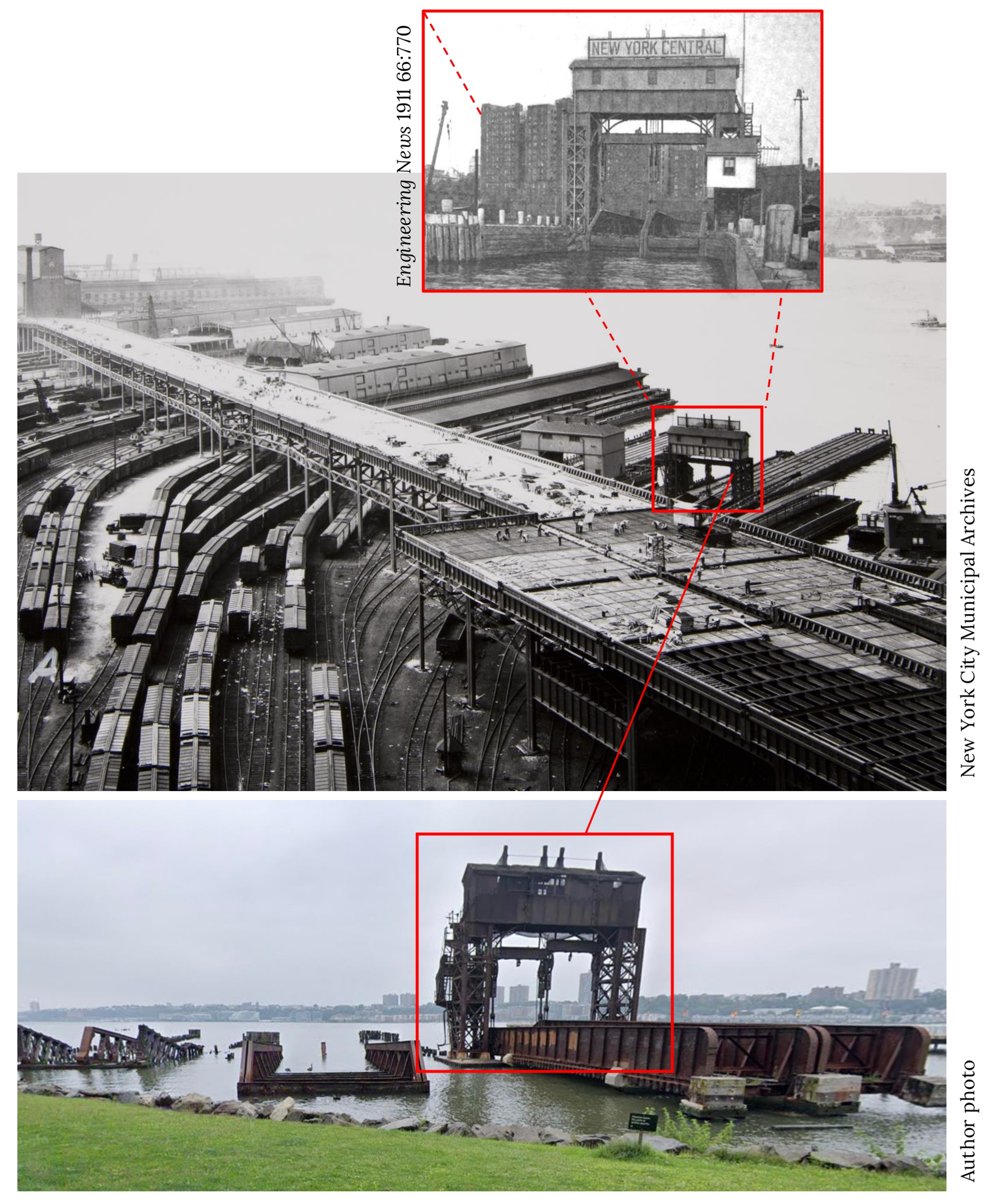
Shoutout to Readers: as they say during March Madness, this one was a layup. Jay B identified and correctly named the Rail Transfer Bridge and gave us some good neighborhood details. As to the date, Joanne’s AI query nailed it: 1927. This is taken from the fabulous Hamilton Aerial Map of Manhattan, which bears the date September 1927, so Jay B’s decoding of clues suggesting August was excellent.
…and that’s the story behind the mystery image. Now scroll back to the top of the column and take on your next challenge, Sherlockians! If you’ve missed any columns in this series,If you’ve missed any pictures in this series, here is the complete collection. All photos used by permission.
About the author: Rob Garber has lived on the Upper West Side since the late 20th century and is a member of the Bloomingdale Neighborhood History Group. To learn more, visit their website at upperwestsidehistory.org. All photos in Upper West Side Historical Photo Challenge are used by permission.
Subscribe to West Side Rag’s FREE email newsletter here. And you can Support the Rag here.


Broadway 82-83 rd St. now Barnes & Nobles
I live on 83rd and am at B&N nearly every day. The building does not have an “arched” structure; it was always “boxy.”
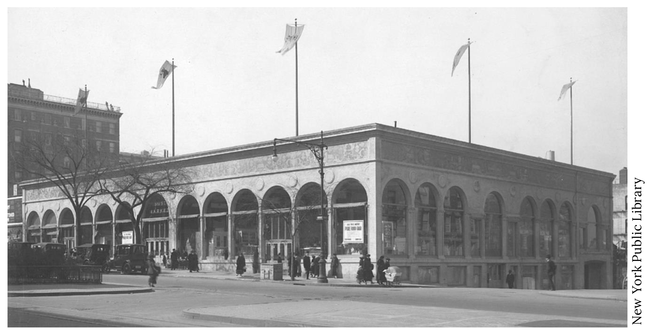
Indoor food market to get the pushcarts off the streets, Southwest corner 95th and broadway where symphony space is now.early 1900s
astor market at w.95th st.
Astor Market at 95th and Broadway. Only open from 1915 – 1917, and it appears open in the photo, so that’s when the photo is from.
You can tell by the slope of 95th street – which retains that angle today.
Symphony Space building SW corner 95 and B’way
Yes!
Astor Market on 95th and Broadway
Since I live right across the street, I believe I’m recognizing the southwest corner of 95th and Broadway, currently occupied by Symphony Space.
In the background would be 250 W. 94th St, known today as “The Stanton” after Elizabeth Cady Stanton, who lived in the building in the photo. It was torn down in 1925 when the current building was erected.
Astor Market at 96th and Broadway. SW corner. Before it became the Symphony Theatre.
Astor Market, at 95th & Broadway, west side. Photo taken between 1910 & 1915 per Library of Congress. The market not a success; Symphony Space now occupies the site
So much less rubbish on the street back then 🙁
Astor Market now Symphony Space
I never saw this photo, but recognize the place as the SW corner of 95th and Broadway. What a thrill to see this! Thanks so much. A rich and wonderful history on that spot.
The slope of the street looks like Bway and 96th.
Is it the Astor Market on Broadway and 95th Street?
Broadway and 95th Street, southwest corner
Astor market, 1915-1917, SW corner of 95th and Broadway where Symphony Space is now.
SW Corner of 96th and Broadway.
I meant 95th and Broadway. Where Petco currently is.
I believe this is the corner of 96th street and Broadway in 1920, looking southwest.
It’s where Symphony Space is now.
It’s amazing all the infrastructure that used to exist in NYC. We used to be a nation that made things and imported and exported. So many middle class jobs lost to globalization and greed.
West die of Broadway between 94th and 95th Streets. Parts are now incorporated under a large apartment building and those remaining parts house Symphony Space. The photo is from the late 1920s, based on the cars in the photo.
Earlier. It has to be pre-1924, the year 250 W. 94th (the building in the background) was demolished.
I’m going to say that this photograph is of the north east corner of 79th St. and Broadway.
How close am I?
An attempt at a food court on B’way and 95th, that failed.
Now Symphony Space.
The former Astor Market on 95th and Broadway, where Symphony Space has been located for years, now.
96th and Broadway
West 94 to 95 Street on the Westside of Broadway. This building was torn down to make way for the Lyric apartment Building with the entrance on West 94th Street.
Being a long time resident of this neighborhood there were many stores that some might know that were there: Shopway grocery store. Baka Bakery, Sal & Carmines Pizza, Tax preparation, a liquor store. Cleopatra’s restaurant.
a 1 bedroom rents for $5,575 per month
2 bedooms rents up to $10,040 per month
South West corner 96th Street and Broadway.
Astor msrket
Wow. Gorgeous. They should have kept that facade and just build above it. It would have stood up more than what it is there now.
95th and Broadway, where Symphony Space is today. Did I nail it?