
By Rob Garber for the Bloomingdale Neighborhood History Group
Welcome to another installment in the Rag’s Historical Photo Challenge. The image above was taken somewhere on the Upper West Side, sometime in the past. Can you figure out where, when, and what it shows? Look closely; this week’s challenge photo, like the others in the series, includes clues that will help you identify the scene, if you’re a dedicated UWS history sleuth. And even if you don’t recognize the picture—not to worry! Come back in two weeks and I’ll decode it, show you the clues that help identify it, and—best of all—tell you a story the image unlocks, because this column isn’t just a test of your neighborhood knowledge; it’s also a rolling celebration of the people, buildings and events that wove the tapestry of the Upper West Side.
Ready? If you think you know where and when the photo was taken and what it shows, post your answer as a comment on this column.
Solution to Historical Photo Challenge #13
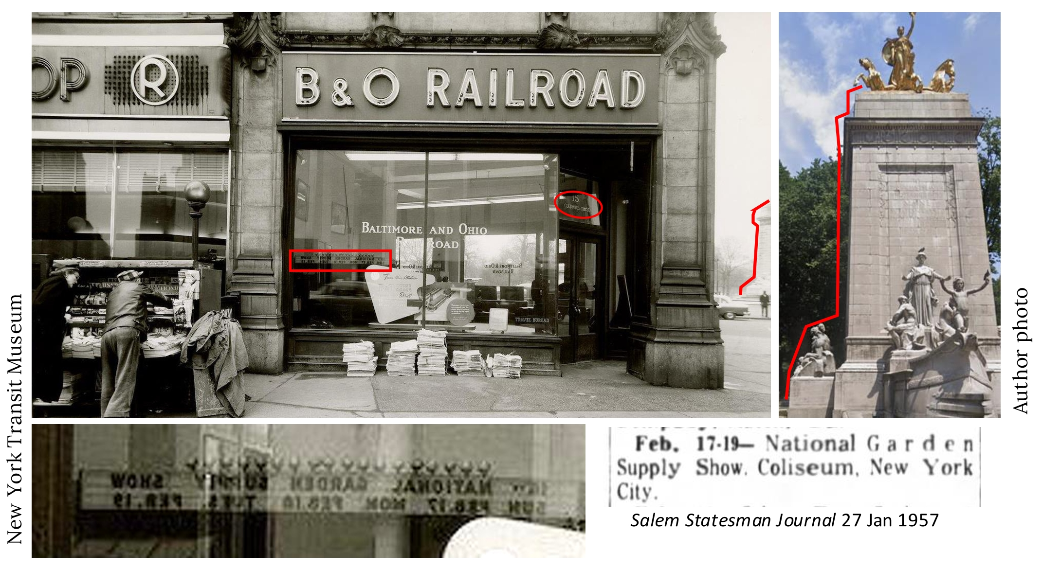
Subject: American Circle Building
Location: 15 Columbus Circle, the east side of Broadway at West 60th Street.
Date: 1957
Image Source: New York Transit Museum
Clues: If you’re north of 70 years old, you might recognize this scene, and the building that housed the B&O office. It was called the Circle Building and on its roof was an enormous Coca Cola sign that perched there until 1966. The subway globe behind the newsstand is a clue, but the key is the glimpse of the Maine Monument at the extreme right: Its profile and clean marble surface is distinctive and familiar. The final clue was for the supersleuths among you: reflected in the B&O window is a marquee that reads:

The internet will tell you that the National Garden Supply Show was held at The Coliseum in New York February 17th to 19th, 1957. The Coliseum was the ugly convention center that New Yorkers loved to hate. It occupied the property where the Deutsche Bank Center (formerly the Time Warner Center) now stands, directly across from the B&O office at 15 Columbus Circle. That 15 Columbus Circle address, by the way, was legible over the door of the B&O office—but that would have been too obvious a clue, so I blurred it.
The rest of the story: Hold on tight—we’re taking a deep dive. William Randolph Hearst came to New York City in 1895 to take over the New York Journal, a newspaper whose offices were on Columbus Circle. Columbus Circle was then considered a business backwater, too far uptown—but Hearst envisioned rebranding it Hearst Plaza to rival Times Square. He bought the property directly across the Circle from the Journal and planned a 30-story tower that would house his business interests. The Depression intervened and the building never progressed past two floors, but it was built sturdily enough to bear the weight of a skyscraper, which meant it could easily support a colossal Coca Cola sign on its roof instead—a sign recognized by millions since it was in place for decades. The Circle building was demolished in 1966, whereupon a remarkable surprise was revealed: a building-within-a-building described as a chapel. David Dunlap wrote about it in 2012 in the Times and speculated that it might have been intended for use by Hearst’s paramour Marion Davies. Does any WSR reader know more about the hidden chapel? The tower that was finally built on the property, described by Dunlap as ”an oversized, silver-and-black gatepost”, was the headquarters of the resource extraction company-turned-entertainment conglomerate Gulf and Western until the late 1990s, when it was taken over by a certain New York real estate developer who now resides in a very exclusive Washington D.C. residence that is getting a very big ballroom.
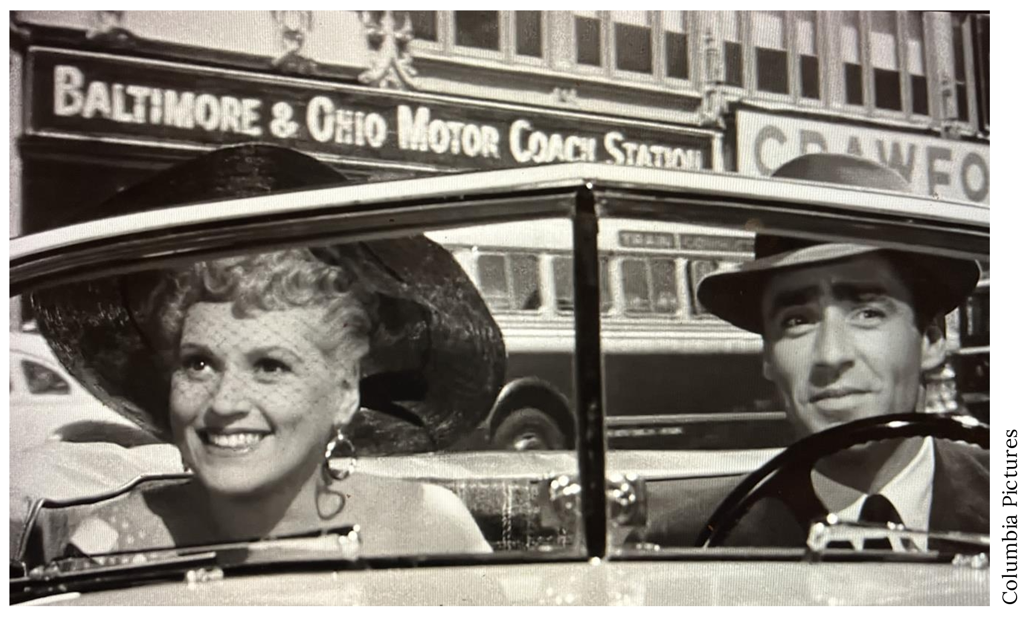
Now, why would there be a railroad office at Columbus Circle? To sell tickets, yes, but the story was much more interesting than that. There’s a two-second glimpse of the side of the B&O office at 27:29 of the 1954 movie “It Should Happen to You.” Note two things in this still from the movie: The building sign reads “Motor Coach Station” and the bus visible behind Peter Lawford has a label reading “Train Connection.”
So, in the early 20th century, when railroads were still the primary mode for long-distance transportation in America, there was an intense battle between the Pennsylvania Railroad and the B&O. Pennsy had primary rights to tracks at Pennsylvania Station, but the United States Railroad Administration, an American experiment with nationalization (the horror!) during World War I, forced them to allow B&O service into Penn Station. B&O and its passengers got accustomed to train service into New York City, and when the Pennsylvania Railroad finally managed to evict B&O from Penn Station in 1926, B&O instituted a service whereby their train customers were bused from the railroad’s Jersey City station into Manhattan or Brooklyn—on ferries across the Hudson! One of B&O’s New York City destinations was at Columbus Circle—thus our photo mystery office was also a waiting room for train passengers en route to destinations like Washington D.C. or Baltimore. The service lasted until 1958.

Shoutout to Readers: I should have known that railroad history would bring out the best in Rag history buffs. Too many of you to list nailed the location, and a hat tip to B.B., Mario Cimino, and EdNY who all know the story of the B&O transfer system better than I do, and to Peter Smode, Jay B, and Alex who read the reflected sign for the Flower Show that gave them the date of the photo.
…and that’s the story behind the mystery image. Now scroll back to the top of the column and take on your next challenge, Sherlockians! If you’ve missed any pictures in this series, here is the complete collection.
About the author: Rob Garber has lived on the Upper West Side since the late 20th century and is a member of the Bloomingdale Neighborhood History Group. To learn more, visit their website at upperwestsidehistory.org. All photos in Upper West Side Historical Photo Challenge are used by permission.
Subscribe to West Side Rag’s FREE email newsletter here. And you can Support the Rag here.


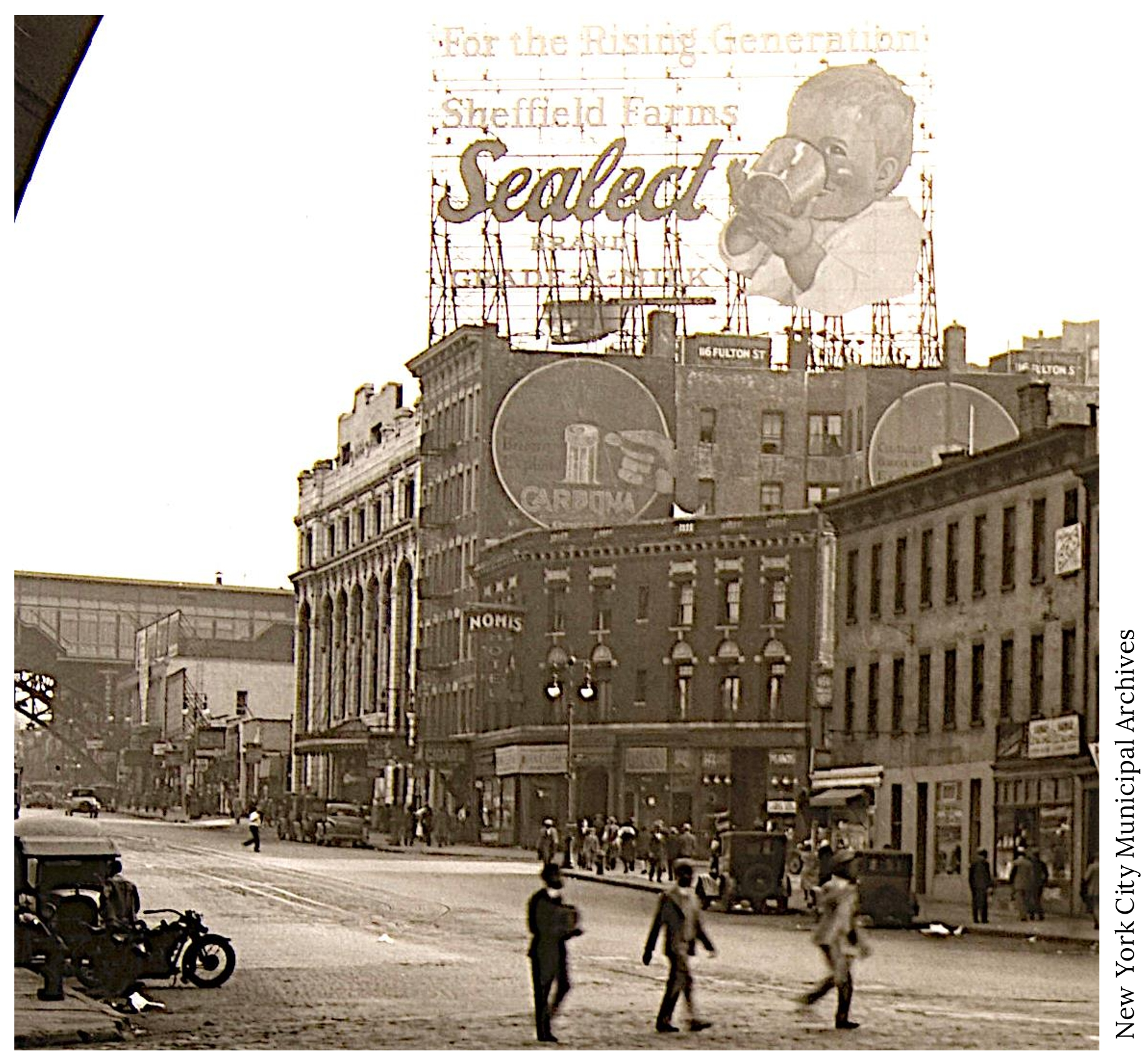
We’re looking roughly southeast along 125th St. toward the IRT viaduct at Broadway. The colonnaded building at center is the Sheffield Farms dairy plant at 632 West 125th St.
You are right, Dave, except it’s looking northwest, I think . Across the street, the property later became an ink plant, I think.
Prentis Hall on the right with the 125th 1 train station in the background; W 125th & W 129th/St. Clair Pl
I believe the photo depicts West 125th St. facing east with Broadway beneath the EL of the subway
125th street and Broadway
Would you consider revealing the identity of the photo at the time you publish it? In two weeks time, I’ve forgotten about it.
Actually, I’d love to see a reprise of the photo when the I.D. is revealed two weeks later. Just so I can can say, “Drat, how did I miss that clue?”
I would have agreed with Dave Cook, et al, except that I see no sign of the George Bruce branch of the NYPL, which opened in 1915 on the south side of 125th St, east of Broadway. The viaduct is on Broadway. I’m assuming the intersection in the foreground is Amsterdam Avenue. Totally confused although I live a block south of that intersection! 🙄
125th St where that new Columbia building is.
I just want to say that these challenges are a delight!
125th Street; West of what is now the IRT’s No. 1 125th Street station.
Hotel Nomis was at 650 w 125 so it was on the south side of 125th and thus the photo is looking east at the Broadway viaduct. As to the date: Carbona was invented in 1908 and the Sheffield Farms bottling plant was build in 1909.
Was the Hotel Nomis also once known as the Edgewater Hotel? About all I know of the place is that to phone it 1918, one called 649-Morningside. Any idea when it opened?
agree!
Upper West Side where Columbia is now. Early 1900’s? Advertising Sheffield Milk
Broadway. Etween 126 and 128 Streets
The Nomis Hotel (note the sign on the right) at 650 w 125th seems to have a checkered past.
Obviously near 116 Fulton Street as on the bldg. probably intersecting Nassau St, in the year 1928 based on the car models and clothing.
Glen W,
Explain the big arch of an elevated “subway”.
It’s likely, as others have pointed out, facing west toward Broadway on 125 Street,
Looks more like “#6 Fulton” to me, and the rest doesn’t add up. (For ONE thing, this is the *UWS* Historical Photo Challenge.)
But I do wonder what Fulton St. has to do with this!
125 St, looking West towards Broadway, and the Elevated IRT station of the 1 train
11/18 mystery photo is West 125th Street, west of Broadway.
125 St. with the IRT elevated train station in the background. This is looking SE between B’way and 12th Ave Riverside Viaduct which is not visible. Looking north would have been the Sinclair ink company with it’s signature smoke stack also not visible. The white building with arched large windows is the Sheffield Dairy which later had an addition along side it and still stands today. I would guess this is in the 1920’s.
P.S.: There’s your missing smoke stack in the NYT photo I linked to below.
Sources give the building’s construction as 1909–11. Do you know when the new wing was added? (It might be that the original section dates to 1909 and the addition to 1911, implying the photo was taken in the 1909–11 range.)
Originally: https://static01.nyt.com/images/2008/01/11/realestate/13scap-2-650.jpg
Today: https://michaelminn.net/newyork/areas/uptown/dairies/sheffield-dairy/2007-10-16_16-37-03_corrected.jpg
Note not only the new wing but also the change to the pediment, originally with a mast rising behind it.
This is West 125th Street between Broadway and Marginal Street. (It wasn’t renamed as 125th Street until the Grant Houses were built in the 1950s and cut off the western end of that street, causing renaming of various streets in the area.) Sheffield Farms was supplied by horse-drawn milk carts coming from the 125th Street dock (milk supplied by cows in New Jersey), which is now a city waterside park. The horses and carts were based in Prentiss Hall — the white marble building under the Sheffield advertisement. Prentiss is part of Columbia U. and is landmarked due to its contributions to getting fresh milk to mothers in Manhattan in the days before refrigeration.
The steel arch in the back of the photo is the support for the #1 subway line that is above ground only for the 125th Street stop, due to the deep valley it crosses. That was built in 1904. I imagine the photo was taken between then and around 1920.
I’ve read that Manhattan Street was renamed West 125th in 1920, not 1950.
To my mind Prentis Hall deserves its landmark status for further reasons: it was later home to both a WW2-era nuclear testing lab and Columbia’s Computer Music Center.
125th on the west side. Facing east. IRT seen. The McDonald’s would have been on the just below the subway bride on the right. Many years later of course, and then gone much to the dismay of many taxi drivers who would stop to eat and get coffee. The McD’s is back but now within a Comumbia building of course.
This being my neighborhood for many years my first instinct from muscle memory or walking in this area so much was the above, but then I thought maybe it was the opposite direction… facing west with Old Broadway and such so I looked it up. As much as I dislike Columbia and all of the awful Eastern bloc looking buildings they have constructed in this area they do have a little documentary about Sheffield Farms and the Milk Industry here as well as an exhibit on this area.
I always wondered what that building that still stands is which is a Columbia building and says Prentis Hall, was the Sheffield Milk Plant.
Here are some links if interested:
https://sheffieldfarms.neighbors.columbia.edu
https://sheffieldfarms.neighbors.columbia.edu/content/chapter-3-manhattanville-transforms
Thank you Rob Garber for informing me!
125 th street and Broadway
Wild Child…125th Street, just West or East of Broadway?
East of B’way facing West. So north is to the right.
Those are not just “blacks”, so to speak. Look closer. They are ALL VERY NAPPY DRESSED TO THE NINES SERIOUS Struttin’ DUDES! West Harlem BIZ MEN…NOT recommended to go up to them with an attitude…lol…Right down the street used to be a super famous and infamous BLACK JAZZ CLUB! I think all the MAJOR Jazz & TORCH SINGERS used to perform there, right off the river. I think it had “Meatballs & Spaghetti”, as a menu item the Limited Partners liked…. The original COTTON CLUB? That would be my pick…. LOL…I grew up in Hamilton Heights, only months after this picture was taken…as I recall?
Manhattanville, Morningside Heights, gateway to West Harlem, but not exactly Upper West Side, no?
Looks like it could be 125th Street facing east coming from RSD. The elevated subway plus the tall pillared limestone building on the right are possible clues. The building still stands as does the the elevated IRT #1 line.
I’d place the photo’s point of view right about here: https://mapper.acme.com/?ll=40.81720,-73.95961&z=17&t=M&marker0=40.81720%2C-73.95961 — again, facing southeast along what then might still have been Manhattan Street.
125 street facing Westside towards Broadway. IRT Station in background.
Looking east, from under the Riverside drive overpass (note the arched girder at the top left corner of the photo). I found this 1925 map of 125th st. , including the intersection of St. Clair that creates the oblique corner of the hotel. Worth zooming in: https://wardmaps.com/collections/atlas-of-manhattan-new-york-1925/products/manhattan-new-york-1925-plate-144
As for year…I’m pushing to 1930. The car driving toward the 1 train could be a 1930 Chevy AD Roadster. I’m having trouble with the little convertible parked in front of the hotel. It looks like the trunk narrows slightly, which wasn’t true of any of the roadsters I’ve looked up yet (Model A, Chrysler 70, Packard, Lincoln, Cadillac, Buick).
This is an easier one! 125th and St Clair Pl looking east towards the IRT Broadway Line/1 Train.