

By Rob Garber for the Bloomingdale Neighborhood History Group
Welcome to another installment in the Rag’s Historical Photo Challenge. The image above was taken somewhere on the Upper West Side, sometime in the past. Can you figure out where, when, and what it shows? Look closely; this week’s challenge photo, like the others in the series, includes clues that will help you identify the scene, if you’re a dedicated UWS history sleuth. And even if you don’t recognize the picture—not to worry! Come back in two weeks and I’ll decode it, show you the clues that help identify it, and—best of all—tell you a story the image unlocks, because this column isn’t just a test of your neighborhood knowledge; it’s also a rolling celebration of the people, buildings and events that wove the tapestry of the Upper West Side.
Ready? If you think you know where and when the photo was taken and what it shows, post your answer as a comment on this column.
Solution to Historical Photo Challenge #9
Subject: Rock outcrop
Location: West 93rd and 94th Streets just east of Riverside Drive
Date: 1900-1903
Image Source: Museum of the City of New York
Clues: Two buildings adjacent to the outcrop still stand: 316 West 94th, with distinctive alternating white and red stripes, and 317 West 93rd, recognizable by the cartouche adorning its second-floor bay windows.

The rest of the story: Rock outcrops in Upper Manhattan were—and still are—a result of the inflexible grid of the city’s 1811 Commissioners’ Plan meeting the reality of tough Manhattan schist. As development moved north in the second half of the 19th century, soil and rock had to be scraped, lifted, and blasted away to produce the generally level topography that we see today. For example, in 1851 a classified ad in the Daily Herald solicited proposals “for excavating and removing the rock on west side of Eighth avenue, between Fifty-seventh and Fifty-ninth streets, to a grade two feet below the present grade of the avenue.”
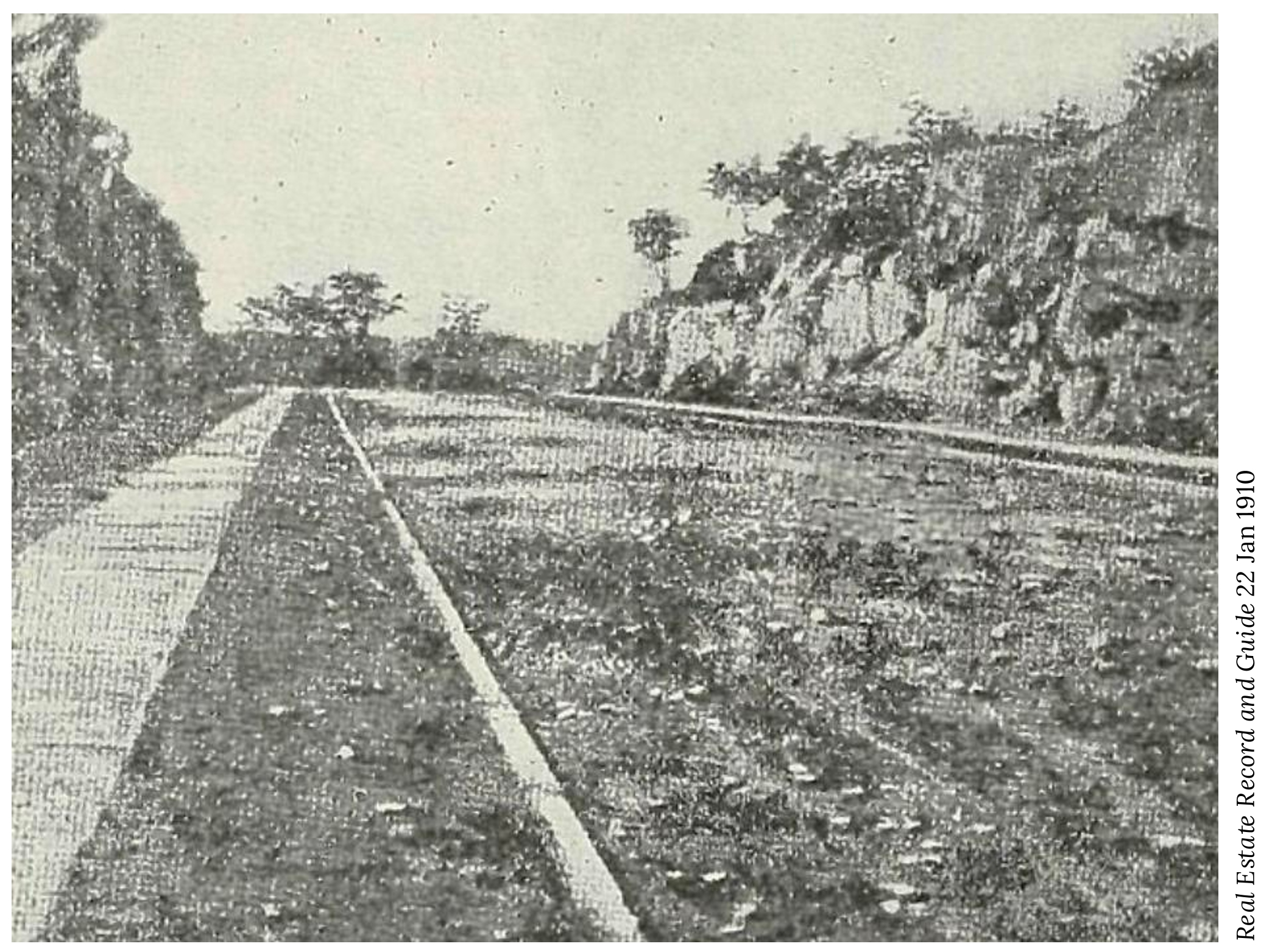
Property owners were assessed the costs of performing the work necessary to “open” streets where their land lay, and they were also responsible for leveling their lots. An 1889 ad in the New York Herald offered “The choicest and cheapest corner plot on Riverside Drive…No rock. Terms easy.” In some cases, owners couldn’t or wouldn’t clear their property, and rock outcrops such as the one between West 93rd and 94th were the result. These weren’t unusual geological phenomena—they were natural features that looked odd only when the surrounding land was removed. The rock in last week’s two mystery photos was in fact a single outcrop that stretched all the way from 93rd to 94th. By 1903, it presented a bizarre spectacle squeezed between neighboring buildings, but a determined developer finally cleared it, and the space was filled by 325 West 93rd and The Vancouver at 314 West 94th.
Dynamite blasting was a familiar annoyance and occasional hazard of UWS life during the decades of rapid urbanization—for example, the New York Times of October 8th, 1908 reported on a “terrific” blast at 507 West 113th Street. “The entire neighborhood was shaken and rocks of all sizes were thrown high into the air … One stone weighing several pounds crashed through the window of the apartment of Mrs. W.C. Porter, on the third floor, and broke several articles on the wall.” The explosion was investigated by the delightfully-named Bureau of Combustibles, which ordered the arrest of the work crew’s foreman. The consequences of errant blasts were sometimes much more severe: On June 22, 1888, an explosion on Riverside Drive at 88th Street resulted in the death of James O’Brien, 50, who was “blown into the air, minus his arm,” leaving a wife and five children.
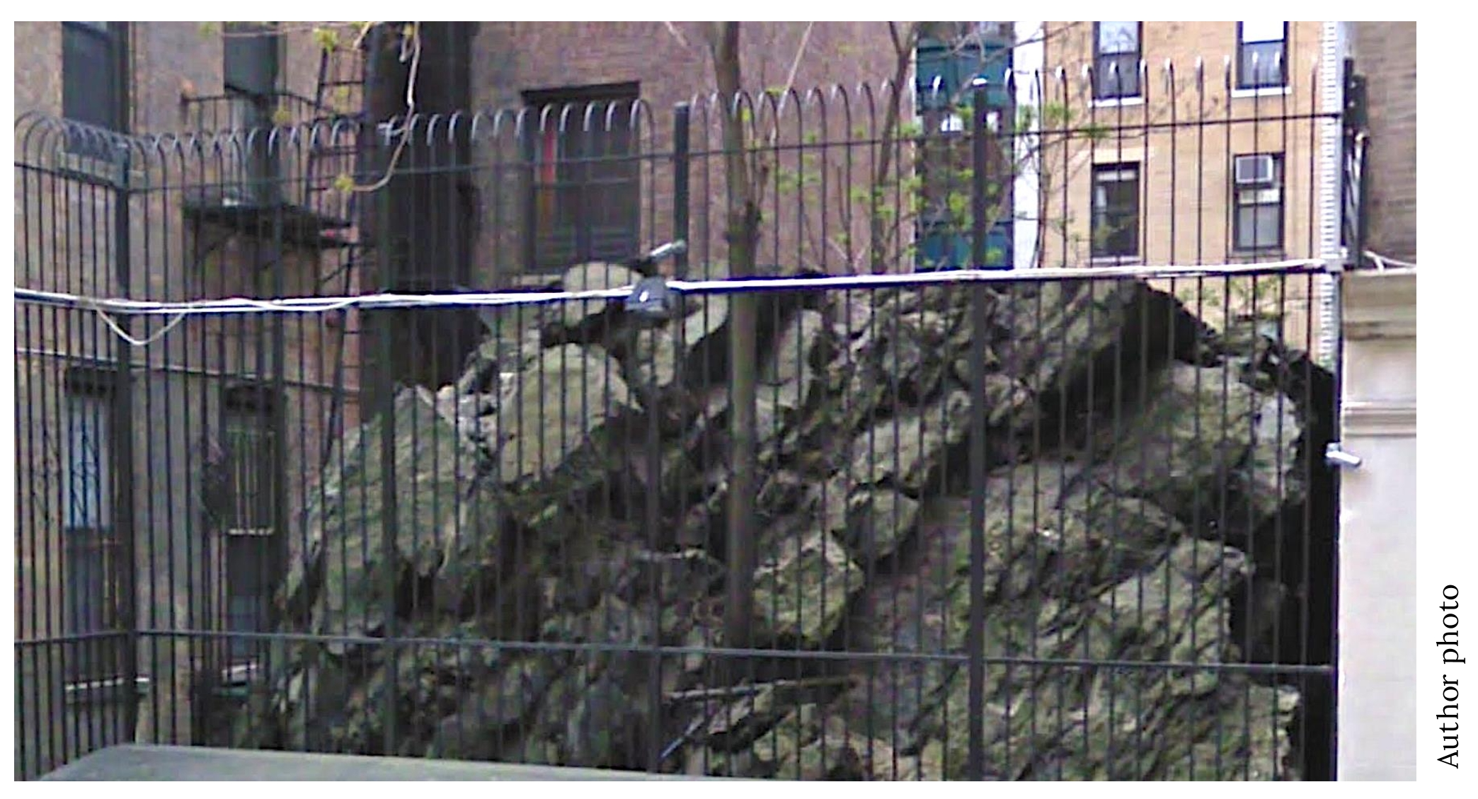
Upper West Side residents know that a few outcrops remain, such as Rat Rock between 600 and 604 West 114th Street, named for the beloved furry critters that call it home.
Shoutout to Readers: Elgin93, Bill Tatum, Tricia K and Ann K all correctly located the rock outcrop on West 93rd/94th Street; hat tip to ecm who recognized the photos from the Museum of the City of New York’s fabulous Greatest Grid exhibit and book several years ago.
…and that’s the story behind the mystery image. Now scroll back to the top of the column and take on your next challenge, Sherlockians! If you’ve missed any pictures in this series, here is the complete collection.
About the author: Rob Garber has lived on the Upper West Side since the late 20th century and is a member of the Bloomingdale Neighborhood History Group. To learn more, visit their website at upperwestsidehistory.org. All photos in Upper West Side Historical Photo Challenge are used by permission.
Subscribe to West Side Rag’s FREE email newsletter here. And you can Support the Rag here.


These are the 9th Avenue Elevated tracks at approximately 8th Avenue @ Cathedral Parkway (110th Street). Most of the line was demolished in 1940, so this photo looks to be about the 20s-30s era.
Streeteasy and other real estate websites list 317 West 93rd Street as having been built in 1910, but the photos are from 1900-1903! Which is it?
Both: the photos predate the buildings. That’s why you don’t see them there.
Real estate websites aren’t particularly reliable sources of historical data. 317 West 93rd Street, also known as Eleanor Court, is shown on a Bromley fire insurance map from 1908, and in newspaper stories earlier than 1910 (for example a New York Times article on 12 Nov 1903 noted the sale of “two seven-story apartment houses at 309 to 317 West Ninety-third Street” and an Evening World article on 30 Mar 1908 described the arrest of Edwin Buckney Hall, “a publisher, of No. 317 West Ninety-third street”, in his “beautiful apartment in Eleanor Court”, charged with attempted suicide.
Thank you Rob!
Even so, built after the photos were taken, thus their absence is no mystery.
Hey, Rob, how can I find out the identity of the business at 360 Amsterdam Ave. (NW cor. 77th) in 1979, this being among the chiefest of my life’s ambitions?
Even so, built after the photos were taken.
Hey, Rob, how can I find out the name of the business at 360 Amsterdam Ave. (NW cor. 77th St.) in 1979, that being among the chiefest of my life’s ambitions?
Here’s a few things at that location over the decades, though none was definitively there in 1979: In the late 1960’s there was Herman Schloss’s upholstery shop as well as Isabel’s hair salon, followed by Art Renovation. In the early 1970’s Ernesto’s Restaurant and also Lecour’s Hair Clinic. By the early 1980s a Super Runner’s Shop. If none of those fit the bill, the good people at the Facebook page Growing Up on the Old Upper West Side will surely remember.
Rob: Thank you greatly for the information! I had known about Ernesto’s from a 1973 NYT restaurant-inspection piece and it remains my leading candidate, but given the way restaurants come and go in this city, I can’t be confident it was still there in 1979–80. Other suggestions I’ve heard include La Maravilla, Rancho Alegre, Los Dos Hermanos (after a diagonal move from the current Chirping Chicken site), and even (in its early days) La Caridad. (The Cottage arrived there in 1982.) Thanks also for the “Growing Up on the Old Upper West Side” suggestion, but I block Facebook at the DNS level, such is my quirky aversion to the place. I guess Eneresto’s will remain the top possibility. My mystery restaurant made scrumptious huevos rancheros I enjoyed in my earliest NYC days.
ecm, 317 W 93rd St is literally in the photo taken from W 93rd St and is used to identify the location of the rocky outcrop that will later become 325 W 93rd St.
My apologies; you are absolutely right. I had been looking at the streetscape from the wrong perspective, spotted the 1910 Stratford-Avon (which of course looks nothing like 317 W. 93rd), and had concluded that settled it. Nope!
In compensation, Joel & Rob, I offer you my 2nd-favorite Manhattan streetside outcropping — more than the one east of CPW near the Beresford but less than Poe’s Mount Tom: https://thegreatestgrid.mcny.org/greatest-grid/outcroppings/55 .
This is wild! Amazing it never got developed
This is the Big Turn at 110th Street on the Ninth Avenue El.
Photo Challenge #10
Columbus Ave 109th-110th St
Every time someone wonders why we don’t have underground parking structures up here, they should be directed to this story!
Suicide Curve where the Eighth Avenue el swung over to 9th Ave. It was the highest point of all the elevated trains (100 ft). It was torn down in 1940 and the scrap sold to Japan so it could be fired back on US troops during WW2 (I heard that story plenty of times growing up). It was called the Suicide Curve because people used to jump off it.
William Carlos Williams wrote a poem about the steel of the EL being sold to the Japanese.
Bill is correct! The photographer is on Eighth and 111th, looking southwest. The building in the foreground, between 110th and 111th, has been replaced, but the two apartment buildings in the background, at the southwest corner of Columbus and 110th (extending down to 109th) are still there. That is where the El turned onto Columbus. These two turns, which required the train to travel over the corners of the blocks, were known as the Suicide Curve. On the corner of 110th and Columbus, to this day, you can still see where the curve prevented tall architecture across the triangular section of the block where the train needed the space to turn. As Bill said, the exact date is tough to pinpoint, but it had to be before 1940, when this section of the El was demolished.
https://en.m.wikipedia.org/wiki/110th_Street_station_(IRT_Ninth_Avenue_Line)
That postcard photo of the el tracks running alongside Morningside Park is astonishing. The tracks were incredibly high! No wonder it was a suicide magnet. Thanks for the link.
S curve from 9th Avenue El as it snaked from Columbus Ave (9th Avenue) along 110th Street, turning left (North) along Manhattan Avenue. Judging by lettering on the billboards/signs, probably from 1920s.
Lion brewery
That’s the Ninth Avenue El track running past the old Lion Brewery near W 107th and Ninth.
Chat GPT nailed this one lol Columbus Avenue and West 109 or 110th Street…part of the IRT Ninth Avenue Elevated Line before it was demolished. Photo taken sometime from 1920-1940
Suicide curve 109th St and Columbus ave Ninth Ave EL looking north to 110th ST
This is the Suicide Curve at 110th Street / Columbus Ave. The building in the foreground looks to be the building located at 71 W. 109th Street. It appears that the photo would be prior to St. John the Divine being completed
8th Avenue and Cathedral Parkway 1923
Rob: “[…] ecm who recognized the photos from the Museum of the City of New York’s fabulous Greatest Grid exhibit and book several years ago.” Thanks, but actually I recalled the outcropping from a 2021 article at Ephemeral New York and then was lucky enough to find the matching photos and confirming text elsewhere.
Suicide Curve of the Ninth Ave El at 110th at 8th Ave. Lion Brewery at 107th St visible in the background – now the site of a public school. An interesting remnant of the El curve is visible looking southeast from 110th and Columbus past the one story storefronts. The buildings that were erected at the sharp curve at 109th after the El was erected are all chopped off at angles. Old photos show the curving tracks passing within mere feet of some upper windows.
Cathedral Parkway & Morningside Drive
There seems to be disagreement about whether it’s Columbus Ave looking NE or 8th ave looking SW. My vote is Columbus, since you can see part of the 110th St station which I think was on the north side of the street. The foreground building also looks a lot like 999 Columbus Ave although it’s interesting that the architectural detailing of the facade is completely different from what’s there now.
I take it back, others have pointed out the Lion Brewery in the background (despite the logo being blurred out) which means it has to be 8th ave facing SW.
Let’s get to something important . The Radels Music Shop sign. What is that object in the picture. It looks like an Egyptian mummy case.
Doing a little research, I see that there used to be listening booths in record stores. A customer could listen to a record before buying it. I think that may be what the picture shows.
Is that an LP (78) next to it or a cymbal?
I like the ad for the music store. Sadly, a thing of the past.
111th street and 8th avenue looking west. It is suicide curve, but you can see the buildings going towards Columbus (9th avenue) in the distance. This building the train is wrapping around had to have been torn down, by the mid century, this intersection had a row of street level 1-2 story businesses. By the late 1980’s, when they were torn down to make way for Towers on the Park, this whole stretch and most of the avenues around were almost completely abandoned. Nowadays you can’t get a 1 bedroom for less than $3,500.
I was also thinking 110th Street because I know there was a dramatic turn at that spot.