
The NYPD has released a map showing the number of crimes in each neighborhood in the city, allowing users to zoom in to the street level.
The Upper West Side is one of the safest neighborhoods in the city, with less than 1 major felony victim for every 1,000 residents in both the 20th and 24th precincts for the month of October. The felonies recorded include murder and non-negligent manslaughter, rape, robbery, felonious assault, burglary, grand larceny and grand larceny motor vehicle.
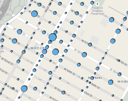
Crime hotspots in the neighborhood include 96th street and Broadway, where five grand larcenies were recorded in October and 26 total felonies were recorded for the year. In fact, all of the major subway stops had high crime rates, with 35 felonies recorded this year at Columbus Circle and a cluster around 72nd and Broadway too. No details about the crimes are available.
Click here to check out the map. It has monthly data from January 2012 to October 2013, as well as data for all of 2012, and theis year through October. Zoom in to see the blue “hotspot” bubbles that show street-level data (when the map is larger it shows precinct-level data).
The police released the data to comply with a law passed by the City Council. It’s a positive step for the NYPD, but it remains exceedingly difficult to get detailed information on crimes in the city. NYPD gives out scant information, even about violent crimes, and is notorious for “playing favorites with whom it shares data,” as Gothamist put it (despite multiple attempts, they never told us why Abbey Pub was closed down by police). Police have now also forbid local precincts from giving out police blotter data. Bill De Blasio gave the NYPD an F for compliance with Freedom of Information Act Requests. We’ll see if the department is more open with information when he takes the reins.

Re: “Bill De Blasio gave the NYPD an F for compliance with Freedom of Information Act Requests.”
Undoubtedly, many cops would like to give De Blasio an “F” … although that would be just the first character in an 8-character commonly-heard expression.
🙁
So true. I have to admit the Bratton choice is encouraging though. I remain skeptical of de Blasio but Bratton strikes me as serious guy who doesn’t have a lot patience for idiots.
I’m glad you speak so confidently for the rank and file police officer.
A lot of crime on 96th & Bway/ What a surprise!
Yes. The area around 96th & Broadway, where I live, has seen a marked increase in vagrancy & loitering which has coincided with the opening of even more homeless shelters in the neighborhood. The West ’90’s have take some giant steps backward in the last couple of years.
It is interesting to see the somewhat meaningful differences between the West 80s and the West 90s. I have lived in the neighborhood for 15 years, and it has been really depressing to watch the West 90s, especially along Broadway, be slowly and painfully transformed in to one, large outdoor homeless shelter.
It is virtually impossible to walk 6 blocks along Broadway between 86th and 106th without encountering a wandering mass of vagrants, homeless adolescents and general nut cases milling about.
I am confused. Isn’t that what all these old curmeougons want? a return to the 70s chaos on the streets….? bemoaning the death of their bohemian paradise (that never really was).
That and bringing back Isaac Bashivis Singer and the Famous Restaurant.
You show a rather limited picture of the Upper West Side.
Is more of the map available? “Click here” in the body of the article doesn’t yield the same info.
Once you click through to the map, you have to zoom in to get to the more detailed blue dots. Then you can click on the dots to learn more details: https://maps.nyc.gov/crime/