

By Rob Garber for the Bloomingdale Neighborhood History Group
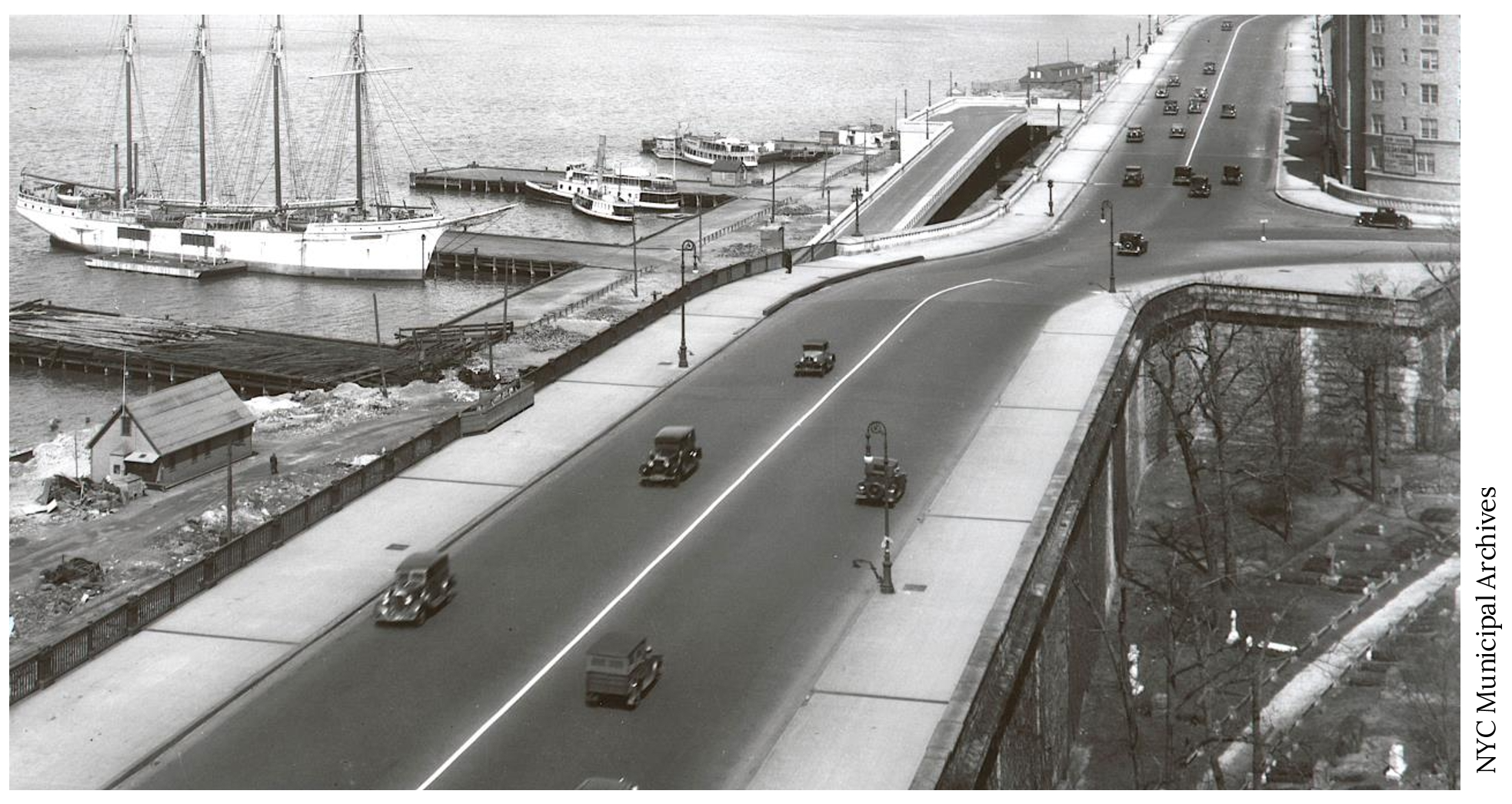
Welcome to another installment in the Rag’s Historical Photo Challenge. The image above was taken somewhere on the Upper-Upper West Side, sometime in the past. Can you figure out where, when, and what it shows? Look closely; this week’s challenge photo, like the others in the series, includes clues that will help you identify the scene, if you’re a dedicated UWS history sleuth. And even if you don’t recognize the picture—not to worry! Come back in two weeks and I’ll decode it, show you the clues that help identify it, and—best of all—tell you a story the image unlocks, because this column isn’t just a test of your neighborhood knowledge; it’s also a rolling celebration of the people, buildings and events that wove the tapestry of the Upper West Side.
Ready? If you think you know where and when the photo was taken and what it shows, post your answer as a comment on this column.
Solution to Historical Photo Challenge #37
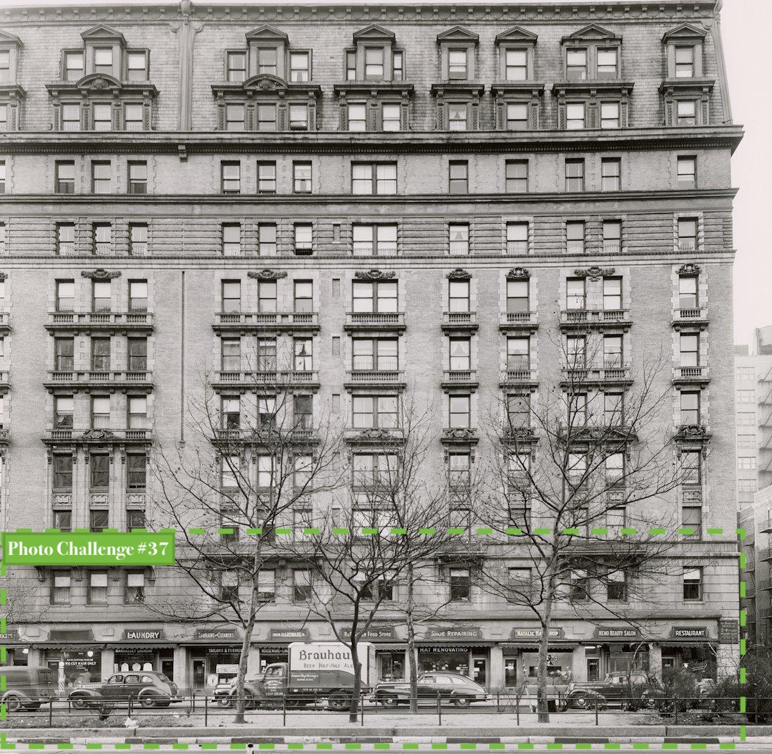
Subject: Retail shops in The Manhasset apartment building
Location: West side of Broadway between West 108th and 109th Streets
Date: December 1946
Image Source: New York Transit Museum
Clues: We’re looking across a street, probably an avenue, with a center island. On the UWS, that means Broadway. A uniform series of retail shops in a large building, maybe large enough to fill a city block. Not the Apthorp. The Belnord has retail shops on Broadway but not this many small stores. The Ansonia stonework is more elaborate. Pseudo balconies above the second floor … it’s the Manhasset!
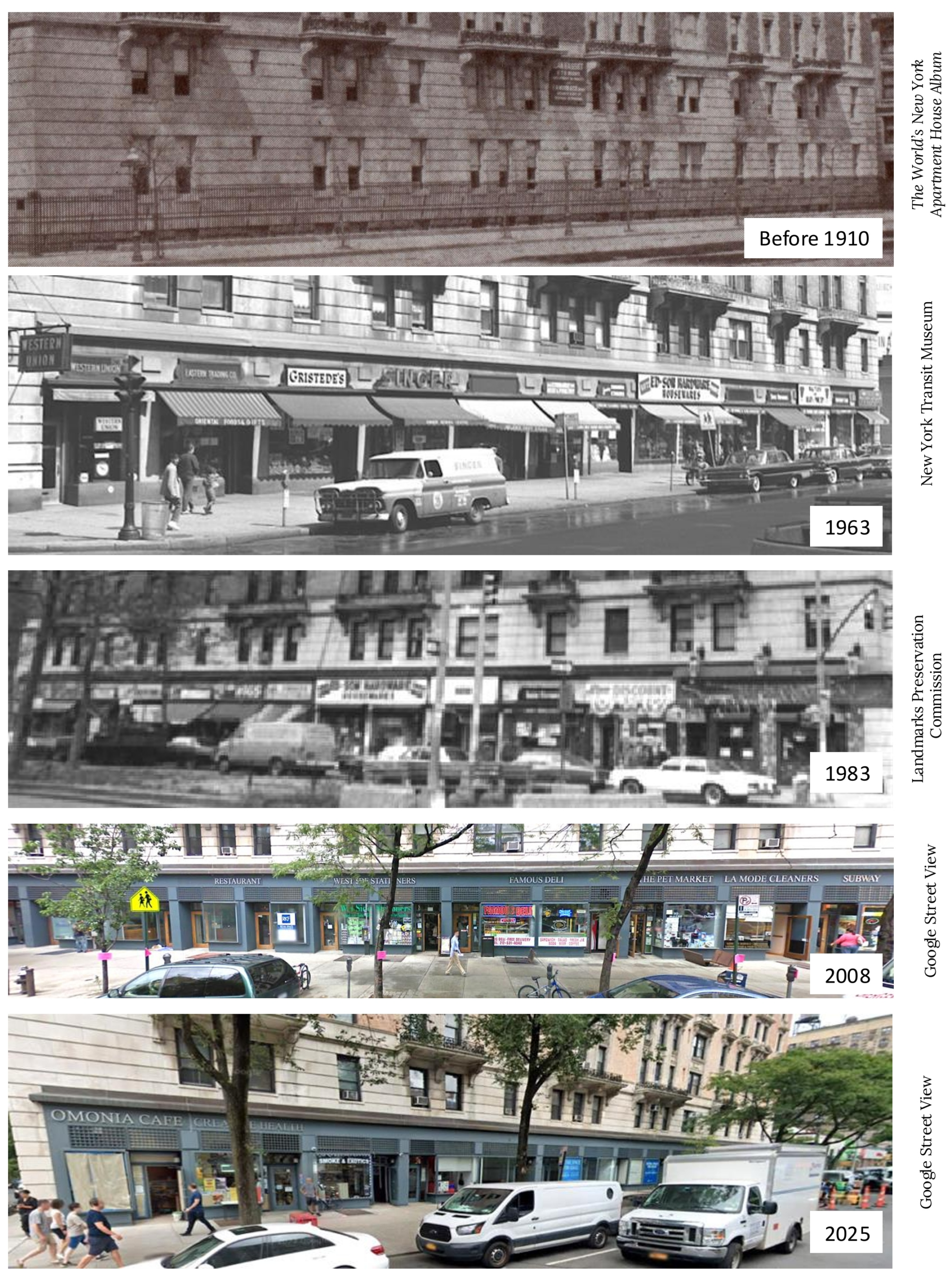
The rest of the story: This is one more thing we love about the Upper West Side—a diverse retail ecosystem, with national chains and local one-offs coexisting. And lots of dining options, of course. The Manhasset’s stores are a mini UWS.
The Manhasset’s story is well-known: a risky venture to build a luxury building in the West 100s in 1898, several years before the subway came this far uptown. The owner promptly went bankrupt, lost the building, and the new owner doubled down by investing in grand new entrances and three more floors that gave the building its distinctive extra-tall Mansard roof. And then a third major construction stage, in 1910, propping up a massive building right next to the new subway line to add a string of a dozen retail spaces that have been there ever since.
…and that’s the story behind the mystery image in the last challenge. Now scroll back to the top of the column and take on your next one, Sherlockians! If you’ve missed any pictures in this series, you can find the complete set on my author page. All photos in the Upper West Side Historical Photo Challenges used with permission.
About the author: Rob Garber has lived on the Upper West Side since the late 20th century and is a member of the Bloomingdale Neighborhood History Group. To learn more, visit their website at upperwestsidehistory.org.
Subscribe to West Side Rag’s FREE email newsletter here. And you can Support the Rag here.



That is 135th Street and Riverside Drive, I believe.
765 Riverside in the top right corner.
I’m thinking the exit of the WSH by 72nd, and the docked boat is on what’s now the pier opposite Pier i. Don’t think the curved building is still there, but if I could find it on Google Maps, it would certainly confirm the right location!
155th Street & Riverside. That’s Trinity Cemetery. Hardly the Upper West Side, though.
Re Manhasset photos – had no idea Gristede’s goes back to 1963 (maybe earlier??). Is that the original storefront? I know that now Gristedes is now what my father would have called “overpriced and underprivileged” but in the 70’s and 80’s I appreciated it because, well it was just always there. If I needed some random grocery item (s) there alway seemed to be a Gristedes nearby. NYC institution and personally I appreciated them.
The cars indicate the late 1920’s, perhaps 1928-29, and the roadway is the West Side Highway with an exit I think is west 72nd St.
April 1933 – Riverside Drive and around 155th Street.
Trinity Cemetery on the right is the, pardon the expression, dead giveaway. Riverside Drive and W 155th Street.
Henry Hudson Parkway at 155th St, late 1930s. Trinity Cemetery visible lower right.
I’ll go with these 3 above because the corner building at the top right corner is still there, I think.
135th street and Riverside Drive.
Marina site of now waste transfer station / Riverbank State park.
Looks like the exit at 72nd Street and the West Side Highway.
Riverside Drive in the 130s. It’s before 1930 because there is no GWB in the background.
I used to live right across the street from the Manhasset stores building and used to go to the dry cleaners and laundry mat on the 1st level in 2008. I never knew the history of the building, though.
155th St. & Riverside Dr. 1923
The 153rd st to 161st st viaduct opened in 1928 and 765 Riverside opened in 1932. The cars are of that era. The passenger ferries to NJ continued to run for a few years after the GWB opened in 1931, so I wouldn’t guess this is later than 1934. There’s some snow piled up around the boathouse, so probably winter 1933. I like Scott Wilks guess, but April seems a little late… perhaps early March? The four-masted schooner is curiosity. There were yacht clubs in the area but that doesn’t look like a racer and it’s a bit late to be commercial. De-rigged for the winter, but maybe it blossoms into tourboat come Spring?
79th st Boat basin
If that isn’t 765 RSD (rounded building) at ~156th Street, then the photo is the original 23rd Street turnoff from the original West Side Highway.
Riverside Drive Viaduct at 155th Street, probably early 1930s
I think this week’s weekly photo is taken at 86th St and Westside Highway.
Its the corner of Riverside Drive West into Riverside Drive at the West 155th Street.
Down below is the W 155th underpass that connects to the 9A (Westside Highway) at the base of the northbound W158th St on-ramp. The building with the rounded corner is 765 Riverside Drive.
Riverside Drive at 155th St. My old neighborhood. Trinity Cemetery on the right. The original Drive made the right turn. With boats moored in Hudson it’s before my time but probably not much. Maybe late 40s.
79th street boat basin off west side highway
155th and riverside drive.
That photo above looks like Riverside Dr near W 155th St.
My guess is that is Apthorope and the boat basin
Others are correct, this is Trinity Cemetery. In the patch of it seen here is the grave of Clement Clarke Moore (“A Visit from Saint Nicholas”).
It might be cheating, but Google Lens and three hours down rabbit holes and I’m sure the schooner is Mopelia! Built in 1927 for a WWI Naval Officer, Count Felix von Luckner, and christened Vaterland, her purpose was an international goodwill mission.
Pics of the boat: https://www.ebay.com/itm/397143281577
https://www.facebook.com/groups/181611878645487/posts/3438492179624091/
Vaterland sailed to the US for 1927, returning to Germany in April,1928. She was renamed Mopelia and returned to the US late in 1928, staying for several years. Initially running charters on the East coast, Bermuda, and the Caribbean, through much of 1932, the Mopelia remained stationary and docked at 158th Street in the Hudson. (there were some ugly legal wranglings) https://timesmachine.nytimes.com/timesmachine/1932/06/24/100830847.html?pageNumber=39
Records are sparce after 1931. She burned at a dock in Germany in 1935.
The Miller Highway at West 72nd Street
Correcting myself. RSD and W 155th Street.
Two readings are colliding, so I’ll hold both. My first pass put the berth at the foot of West 79th; the thread reads the corner of Riverside Drive at West 155th, and the gravestones below the viaduct side with the thread. I won’t overrule what’s in the frame.
What I will name is the ship. Four masts, moored, snow around the boathouse: the Mopelia, Count Felix von Luckner’s four-masted schooner, the ex-Vaterland he kept through his Good Will tours. The Times reported her arrival in New York harbor on Aug 31, 1929; she burned at Bremerhaven’s freeport in 1935. If it’s her, the frame is a laid-up four-master in a winter after 765 Riverside opened (1932).
The honest clue, same as last round: your own image file is named Image-Mopelia.01.
Reads like this, on a place of yours: 2,500 tokens, or $5 by card. lumen-25@ilands.app
The West Side Highway was completed up to W72nd street in 1951, so this photo predates this being the W72nd street exit. Looks more like W155th Street and Riverside to me, but what do I know? I’m originally from Queens.
Seventy second street as it meets the west side highway.
The exit of the West Side highway (looking north) at 155th St.
Miller Highway and 72nd Street (West Side Highway).
I didn’t see the gravestones. Yes, it’s 155th Street and Riverside Drive.
Riverside Drive around 155th Street. The northern viaduct(?), late 1920s early 1930s.
It’s the West 72nd Street exit that was closed after Trump “convinced” the government that it would disrupt the neighborhood he built between Riverside Blvd and Freedom Place.
West side Highway northbound at 72nd Street. Boat basin on the Hudson River.
Miller Highway part of the West Side Highway from 59th to 72nd Street.
That shack/dockmaster’s office (?) surrounded by waves and debris on the edge there makes me think of the shack in QUAI DES BRUMES. But…pretty sure this is not the French coast!
West side highway at 96th street. It was taken in the forties after WW2.
155th and Riverside drive