
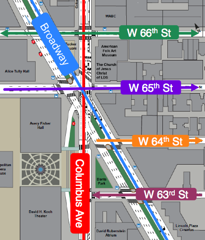
The Department of Transportation has released its full plan to redesign the “bowtie” area on Broadway and Columbus between 66th and 63rd streets. The new crosswalks, extended curbs and changes to the medians are meant to decrease conflicts between pedestrians, bicyclists and vehicles. The area is in the top 5% most dangerous intersections in the city. We wrote about the meeting where the plan was unveiled here.
The plan extends the Columbus Avenue bike lane from 69th street to 62nd, but most of that span would turn it into an unprotected “bike path,” Streetsblog notes. ”We’ve gone from what was a deathtrap, or currently a deathtrap for cyclists, to something that is merely mildly dangerous,” said committee member Ken Coughlin. ”You couldn’t have a protected lane that guides them?” “No,” DOT project manager Rich Carmona replied.
See the full plan below or in pdf form here. The Community Board is likely to vote on it early next year.
2014 12 Lincoln Center Meeting
Let us know your thoughts in the comments.


HOPEFULLY the plans will include REPAVING the side streets east of the “bowtie” (specifically W. 63rd up to W. 67th), as they are currently an abomination.
Anyone using a powered mobility device (yes, like this commenter) has to carefully plan a route to avoid being dumped over by the “craters-of-the-moon” asphalt surface of those streets.
This is NOT what a world-class city should offer even the non-handicapped.
Oh, and it would be nice if Con Ed would finally FIX that darned recurring steam-pipe problem on Columbus just south of W. 66th. It gets tiresome seeing their orange-and-white cat-in-the-hat-like traffic-snarling pipe as semi-permanent street furniture!
If the DOT map is correct, West 66th street between Columbus and CPW is now an Eastbound Street, so I expect there will be a number of head on collsions with cars coming west through the Tranverse. That doesn’t sound too safe to me.
The problem with having a five block gap in an otherwise tolerable protected bike path is that it limits the low-stress network accessibility, which is necessary for bringing more casual potential bicyclists out of the woodwork. A chain is only as strong as its weakest link.
I commend the DOT for having a very thorough design with great improvements for pedestrians, but I am not convinced that a protected bike path is unfeasible. From what I understood, the primary reason why they are reluctant to put a protected path to the left of the southbound traffic on Columbus Ave (east side) is because of the vehicle left-turn conflict going from Columbus to 65th St. The standard treatment for this with a left-hand protected bike path is to split the signal phase between left-turning vehicles and straight-going cyclists. Given that they are already considering adding an eight second leading pedestrian interval (LPI) on the 30 second phase, I fail to see why this can’t be extended to a 15 second LPI and allow cyclists to use this phase as well. Perhaps they are worried about the left-turning vehicle storage not clearing during a single phase, but to me, this seems like a much more trivial concern than the safety of vulnerable road users and the promotion of cycling across the city.
I agree with Steven. Is there an error on W.66 St. The other issue which may not be addressed is the number of vehicles parked outside Lincoln Center. I believe the original plan was to have vehicles enter and wait down the adjacent ramp. Why has this not been enforced. Crossing Broadway in front of a Lincoln Center is dangerous.