 By Rob Garber for the Bloomingdale Neighborhood History Group
Welcome to another installment in the Rag’s Historical Photo Challenge. The image above was taken somewhere on the Upper West Side, sometime in the past. Can you figure out where, when, and what it shows? Look closely; this week’s challenge photo, like the others in the series, includes clues that will help you identify the scene, if you’re a dedicated UWS history sleuth. And even if you don’t recognize the picture—not to worry! Come back in two weeks and I’ll decode it, show you the clues that help identify it, and—best of all—tell you a story the image unlocks, because this column isn’t just a test of your neighborhood knowledge; it’s also a rolling celebration of the people, buildings and events that wove the tapestry of the Upper West Side.
Ready? If you think you know where and when the photo was taken and what it shows, post your answer as a comment on this column.
Solution to Historical Photo Challenge #21
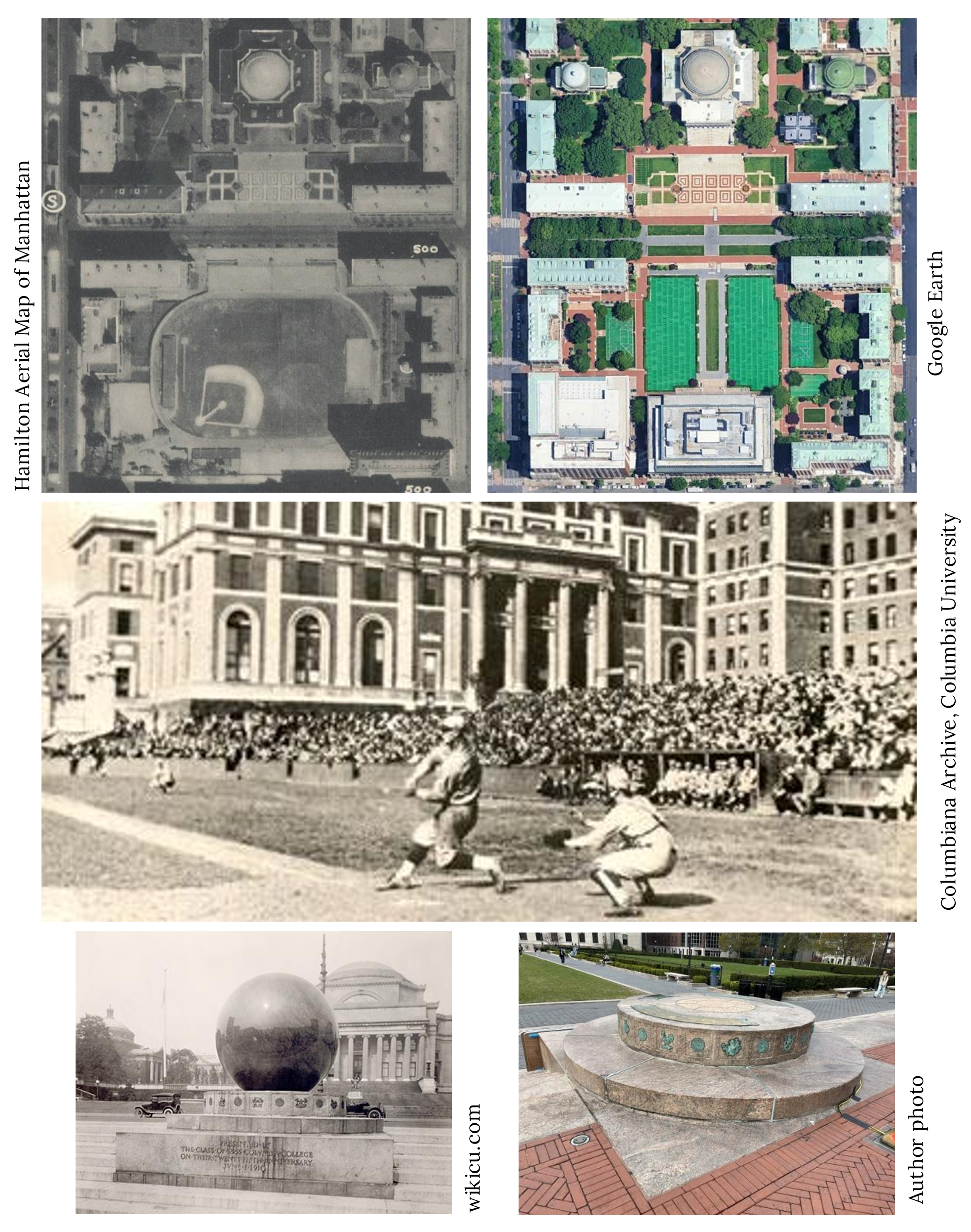
Subject: South Field
Location: Columbia University
Date: Probably 1920s
Image Source: eBay
Clues: Columbia’s campus is so familiar that I had to crop the photo severely to make it a even a slight challenge. There was just enough of Hamilton Hall in the background that its distinctive brick pattern might have been a clue. If you know the story of Columbia’s marble sphere sundial, it’s there towards the left, close to the street that used to be 116th until Columbia President Dwight Eisenhower convinced New York City to turn it over in 1953. The open view to the right is disorienting because it has been blocked since 1934 by Butler Library.
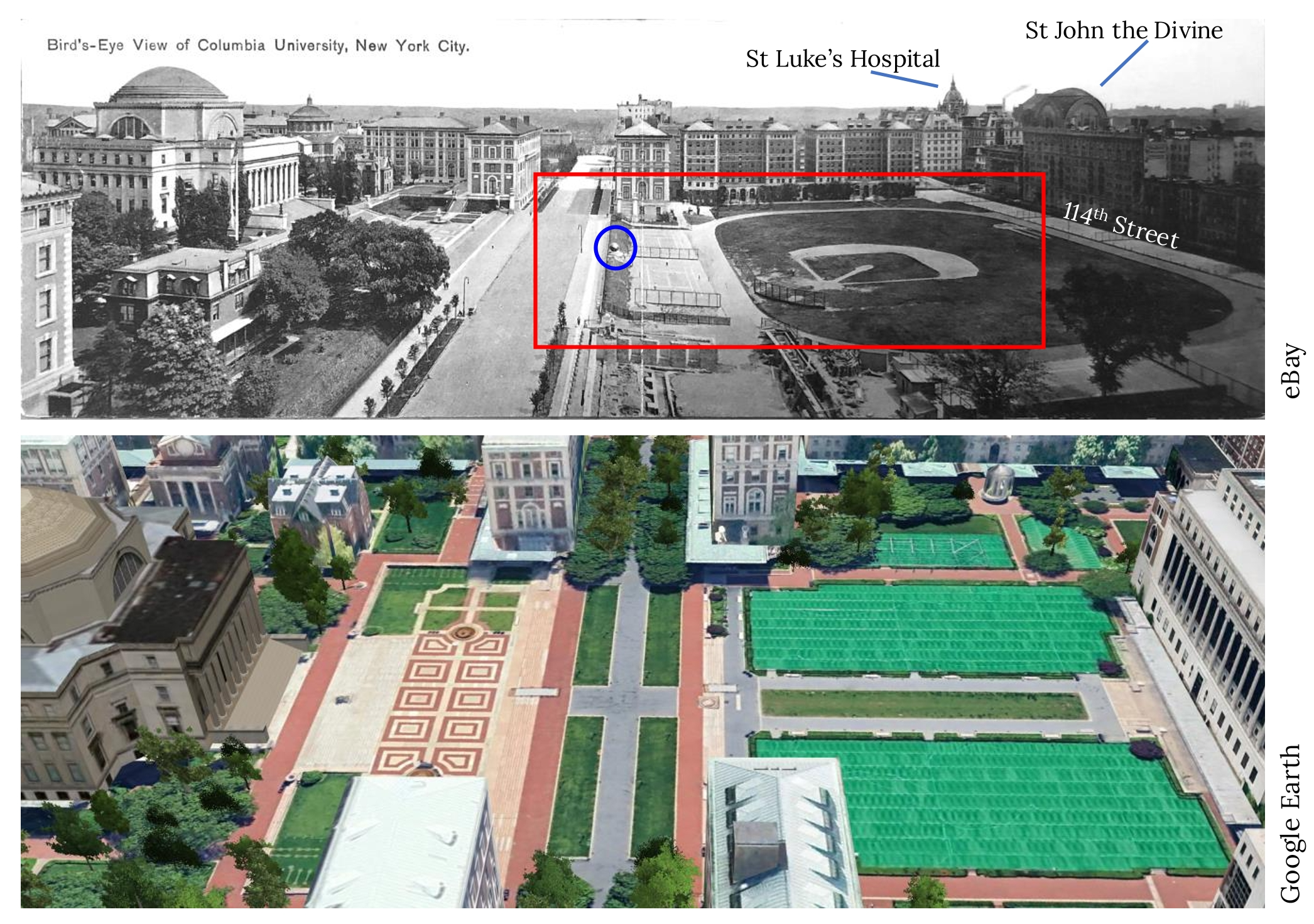
The rest of the story: Two pieces of Columbia lore are evoked by our challenge photo: Lou Gehrig, and . Gehrig played for Columbia until he dropped out in 1923 and signed with the Yankees for $1,500. A 1927 aerial photo, compared with the image of Gehrig at bat with Hamilton Hall behind him (below), shows that the baseball diamond was sometimes swapped 180 degrees. Regarding the sundial—it was a 16-ton marble sphere whose shadow, cast on the base, told the time. Emplaced in 1914, it was a campus fixture until 1946, when cracks were detected and the sphere removed. Apparently, it held together and can still be found intact, in … Michigan. The sphere’s base remains and is known as “the Sundial,” which must confuse new students. It’s a traditional home for student gatherings and protests. Well, used to be.
Shoutout to readers: You needed a breather after Sharkey’s, and identifying South Field in its baseball era posed no challenge to many of you. Tim, Tom Fedorek and ecm all spotted the marble globe, and there was a lively debate about the making of Pride of the Yankees. For anyone interested in a (very) deep dive into the debate about whether Gary Cooper’s scenes as Lou Gehrig on the field were shot in reverse to address Cooper’s ineptitude as a left-hand hitter, take a look at https://baseballresearcher.blogspot.com/2013/02/the-pride-of-yankees-seeknay.html.
…and that’s the story behind the mystery image. Now scroll back to the top of the column and take on your next challenge, Sherlockians! If you’ve missed any columns in this series, here is the complete collection. All photos used by permission.
About the author: Rob Garber has lived on the Upper West Side since the late 20th century and is a member of the Bloomingdale Neighborhood History Group. To learn more, visit their website at upperwestsidehistory.org. All photos in Upper West Side Historical Photo Challenge are used by permission.
Subscribe to West Side Rag’s FREE email newsletter here. And you can Support the Rag here.


60th Street yard?
Future Riverside Park and the area covered over by the Trump Place buildings?
Riverside park rail yards
I cheated and went to the full map online so I know where it was but I’m not sure what it was. Some kind of railyard obviously.
Photo challenge is an aerial view of the 79th St. boat basin
Not to mention rotunda as well
Looks like what is now Riverside Park, below 72nd. In the lower left, the 69th Street transfer bridge (which is still there) is visible.
Winner, chicken dinner
79 Street Boat Basin!
Westside Highway
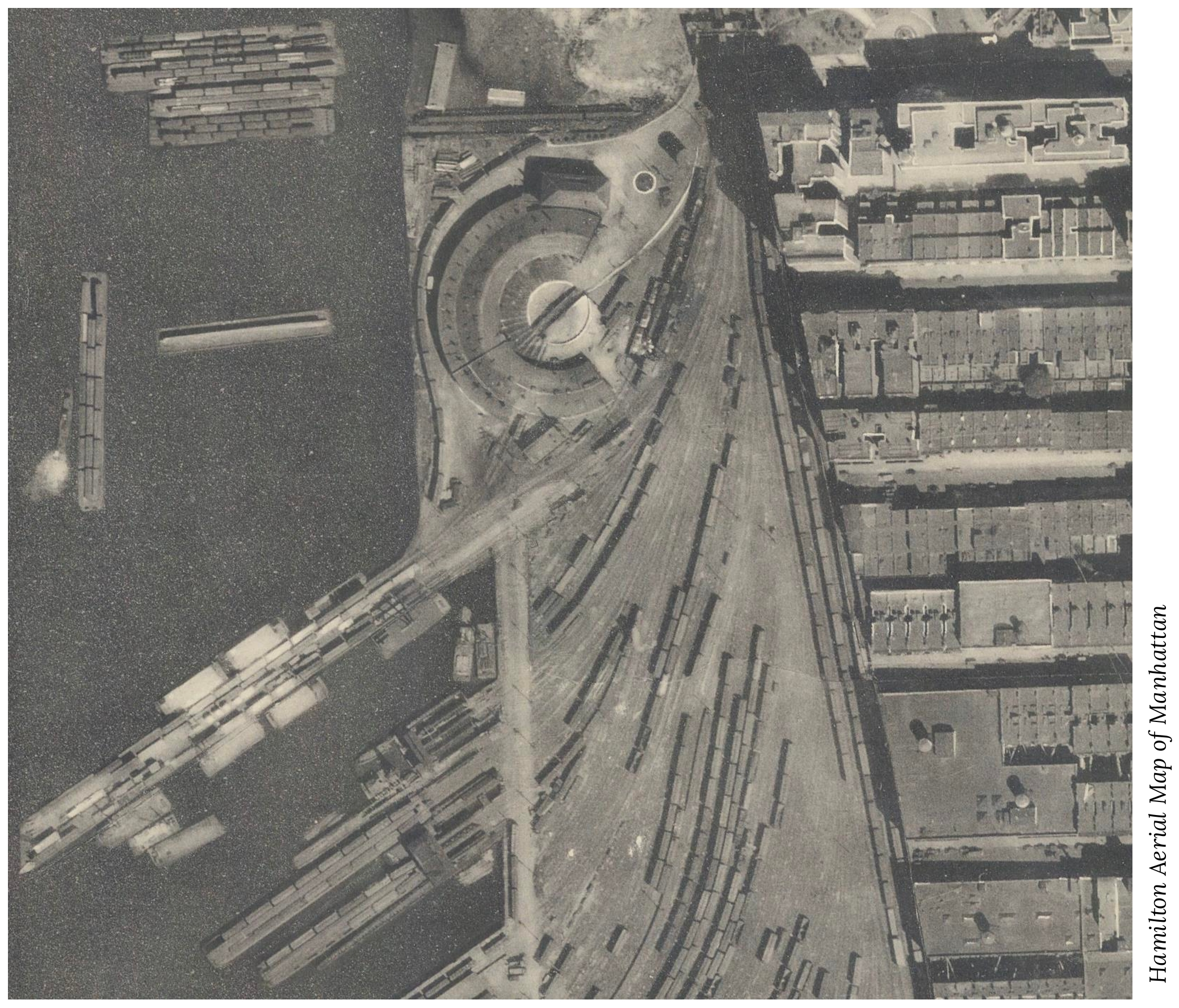
This is approximately the west side of Manhattan between 66 Street and 71 st Street. The year is a wild guess, about 1940. Rail cars were transport across the Hudson with barges. This was also a rail yard where freight rail cars were sorted and joined depending on destination.
The structure in the center near the top, at approximately 71st Street, is a roundhouse, where the New York Central Railroad (later the New York Central System) kept the locomotives that worked in the extensive yards, moving freight cars on and off the barges that carried them across the Hudson River. At the far left, a steam-powered tug is pushing a barge that holds 20 cars. I’m going to guess that the photo was taken in the early 1920s.
The angle of streets and piers suggests that it’s the 70th street pier area. There are remnants of the Railroad Barge pier still there, I guess this is one of the shorter piers on the photo.
It’s before any highways were built so pre-1927?
I agree that it’s the 79th street boat basin. Regarding the previous challenge, I guess the Rag doesn’t want to get into the fact that Columbia has locked up the campus for two years, and will only allow people who are not associated with the university in if you pre-register for an event. I have read that this is illegal, that when 116th street became part of the campus, the city agreed to the change if Columbia agreed to allow the street to be open to anyone who wanted to enter the campus.
https://neighbors.columbia.edu/content/campus-access-form-neighbors
This is the rotunda at 72nd street in what is now Riverside park. It shows the piers that unloaded the barges and connected to the rail lines to delver goods from the west to the east.
72nd street yard and engine facility, now riverside park 1930
New York Central Railroad’s 72nd street yard and engine facility. Now riverside park. Pre 1929 no west side highway
New York Central Railroad’s 72nd Street roundhouse and freight yards along the Hudson River.
72nd st. at the top of the frame, Pier I’s predecessor prominent at lower left, with the Rail Transfer Bridge below that. Among the buildings, the top left, with the odd angles and appendages, is The Chatsworth (1904), immediately to its right is the Chatsworth Annex, built 1920, and then 330 West 72nd, built 1927. I’m not dead certain that a water tank is visible on 330’s roof, leading me to think this photo was taken just before completion. Per Wikipedia’s page on “West Side Elevated Highway”, “The section from 59th Street to 72nd Street was begun in September 1930.” Trains are still visible near the buildings, so the tracks had yet to be cleared.